How does a dry-season farming region end up looking like a new lake in just a few days? In northern Colombia, that is essentially what happened after extreme early February rains transformed large areas of Córdoba, one of the country’s key cattle and agricultural departments, into a broad sheet of floodwater visible from space.
What makes this story so striking is the timing. February is usually one of the driest months in Córdoba, but in 2026 an already wet January was followed by an unusual Caribbean cold front that pushed moisture inland and helped unleash rainfall intense enough to redraw the landscape almost overnight.
A dry month that suddenly looked like a floodplain
For local farmers and ranchers, this is normally the part of the year when fields are prepared for planting and cattle are moved onto drying floodplains. Instead, the seasonal routine was thrown off as floodwater spread across cropland, pasture, and communities near the Sinú River.
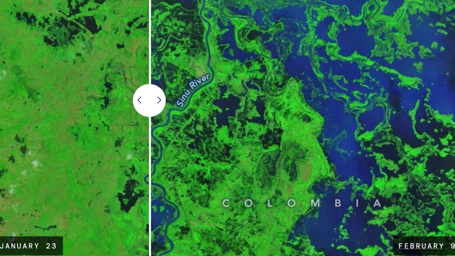
NASA’s Earth Observatory compared Landsat 9 images from January 23 and February 9, and the difference is hard to ignore. In the later false-color view, dark water covers wide stretches of land near Lorica, while wetlands east of the river also appear unusually swollen, creating the impression of a giant new body of water where productive land had been just days earlier.
The unusual weather setup behind the flood
The main trigger appears to have been a cold front that pushed south through the Caribbean on February 1 and 2.
That system forced moisture-laden air into northern Colombia and up against the Andes, a setup that helped produce several days of intense rain, with some areas receiving more than 4 to 7 centimeters a day and rain rates near Lorica reaching 1.7 centimeters per hour during the heaviest burst.
There is also a broader climate question hanging over the event. A rapid attribution analysis from ClimaMeter said the meteorological conditions were very exceptional and suggested similar events in today’s climate are wetter than comparable past episodes, though the researchers also cautioned that confidence is limited because this flood was so unusual in the historical record.
What the flooding meant for farms and families
From above, the flood looks like a dark mirror spread across the countryside. On the ground, it meant something far more immediate, with NASA reporting that more than 80% of Córdoba flooded, while preliminary estimates pointed to thousands of homes destroyed, more than 11,000 families displaced, and more than 150,000 hectares (about 370,700 acres) of farmland inundated.
Colombia’s disaster agency added another important detail. Using satellite-based mapping, the UNGRD estimated that by February 9, the total affected area in Córdoba alone was about 113,641 hectares, which shows just how large the flooded footprint had become even before all impacts were fully counted.
Why the water did not leave quickly
This was not a quick one-day shock that disappeared as soon as the rain eased. NASA noted that storms kept soaking the region in the following weeks, and imagery from the Terra satellite on February 25 still showed flooding spread across the area, suggesting that the water lingered much longer than people might expect from a short burst of bad weather.
In practical terms, that matters a lot. When floodwater stays put, planting gets delayed, livestock movement becomes harder, roads and local transport suffer, and the hit to household life keeps growing even after the skies look calmer again.
Satellites became part of the emergency response
One of the clearest lessons from this disaster is that satellites were not just documenting the damage after the fact. The UNGRD said it activated the International Charter “Space and Major Disasters” and also requested Copernicus emergency mapping, receiving 152 optical and radar products to help define the flood extent and support decisions on the ground.
That kind of mapping can sound technical, but the idea is simple enough. When an entire region is waterlogged and access becomes difficult, accurate satellite images help authorities see which communities, roads, wetlands, and agricultural zones were hit hardest, and that can shape where aid and recovery efforts go first.
A warning hidden inside one flood
This story is about weather, but it is also about exposure. A recent European humanitarian update said more than 200,000 residents in Córdoba were affected by the floods and warned that environmental degradation and weak planning leave vulnerable communities more exposed when rivers spill over and fields suddenly turn into lakes.
At the end of the day, what happened in Córdoba is a vivid reminder that the old seasonal calendar is not always a safe guide anymore. A month that should have been used to prepare land and move cattle instead became a test of emergency response, satellite monitoring, and resilience in one of Colombia’s most important rural regions.
The official statement was published on NASA’s Earth Observatory.