There is a massive oceanic anomaly that is spreading over the North Pacific Ocean, and conditions being formed can help in causing a far colder winter in North America, according to meteorologists. This evolution has been accompanied by the formation of a different polar vortex in the stratosphere, positioning the stage of a dynamic season of Winter 2025/ 2026.
North Pacific warm blob grows into the US coastline
The current marine heatwave, causing many problems to the North Pacific Ocean, is extremely large and spreading drastically throughout the entire territory. This warm event, commonly referred to as a warm anomaly, has caused the temperatures to be way above normal not only in the central Pacific but also as far as the west coast of the United States and Canada.
According to severe weather analysts, there is a strong oceanic anomaly that is travelling across the greatest west of the North Pacific, thus imparting warmer ocean temperatures to the west coast of the United States. The anomaly region is bigger this year than it has been in a long time, and this leaves the question of whether a more severe winter is emerging.
This has already been triggered in the warning category by the coral bleaching alert system, and this is the extent to which this anomaly is of vital importance, considering that it is an event that has occurred throughout the entire North Pacific area.
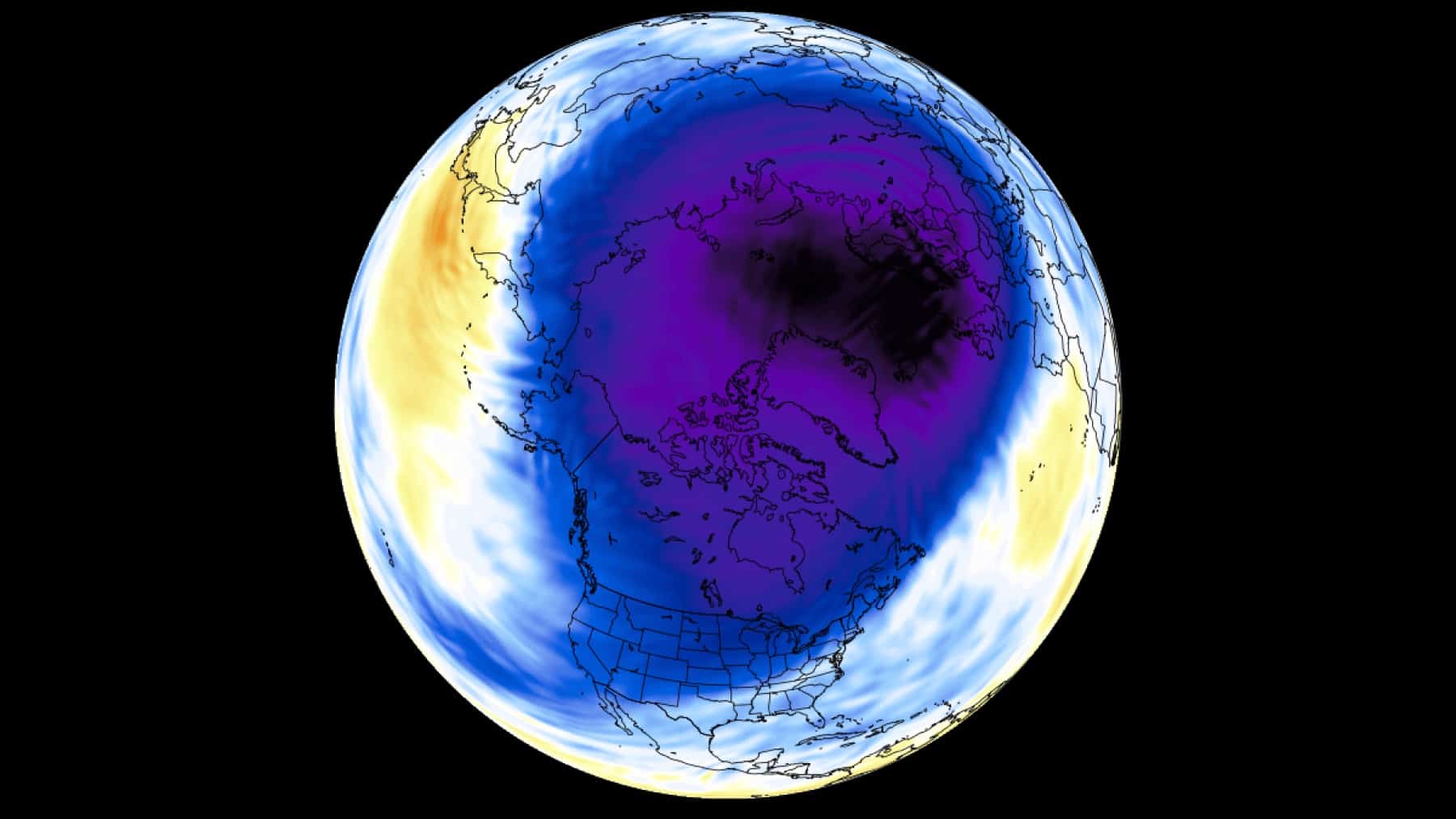
A North Pole Stratospheric polar vortex starts to form
At the same time, a fresh polar vortex is forming in the stratosphere above the North Pole, with the temperature in the polar areas falling miserably quickly. Set off by the initiation of the cooling process that usually starts in August and heightens during September and October, forms the basis of winter weather patterns in the Northern Hemisphere.
According to the report of meteorologists, a new Polar Vortex is already forming in the Stratosphere over the North Pole, as the pressure and temperatures in the polar areas are already dropping. The stratosphere is coolest in November and December, and the polar vortex typically attains maximum strength during these months.
Historical patterns suggest a colder winter ahead for North America
Comparison of previous winters that had the same North Pacific anomalies indicates that there is a steady increase in cold temperatures and higher amounts of snowfall in the United States and Canada. The oceanic anomaly produces an atmospheric bridge that interferes with normal pressure systems and jet stream patterns, as claimed by the scientists.
According to historical data on other similar seasons, it indicates that there was a massive cold air deformation that started moving towards the United States of America after Canada and had already initiated a cross-polar flow, causing the air to move down the polar circle. The outcomes of these conditions are generally excessive snowfalls in the northern, eastern, and south-central United States, and in some areas of western and central Canada.
Several conditions are coinciding with possible polar vortex disruption
Several atmospheric factors are combining to form, that records have shown predispose events of collapsing polar vortexes. A combination of La Niña conditions in the tropical Pacific and a negative state of Quasi-Biennial Oscillation presents a condition that is conducive to sudden stratospheric warming events.
This mix of the huge South Pacific warm anomaly with the developing stratospheric cooling is a combination that left situations like the past winter, where much cold and snow fell on North America. No certainty exists in regards to how much weather will be experienced in a season, but these trends are making some sense that the Winter of 2025/2026 will bring stronger weather conditions in comparison to the recent milder seasons.