In 2022, a remotely-operated vehicle gliding over an underwater mountain north of Hawaiʻi sent back a scene that looked straight out of a fantasy movie. On the summit of Nootka Seamount, inside the vast Papahānaumokuākea Marine National Monument, cameras revealed what seemed to be a neatly paved yellow brick road running across a dried lakebed on the seafloor.
The scientists aboard the exploration vessel Nautilus joked about Atlantis and the road to Oz while the video streamed live online. Viewers around the world could watch in real time as the vehicle inched along the strangely familiar pattern, more than a kilometer beneath the ocean surface.
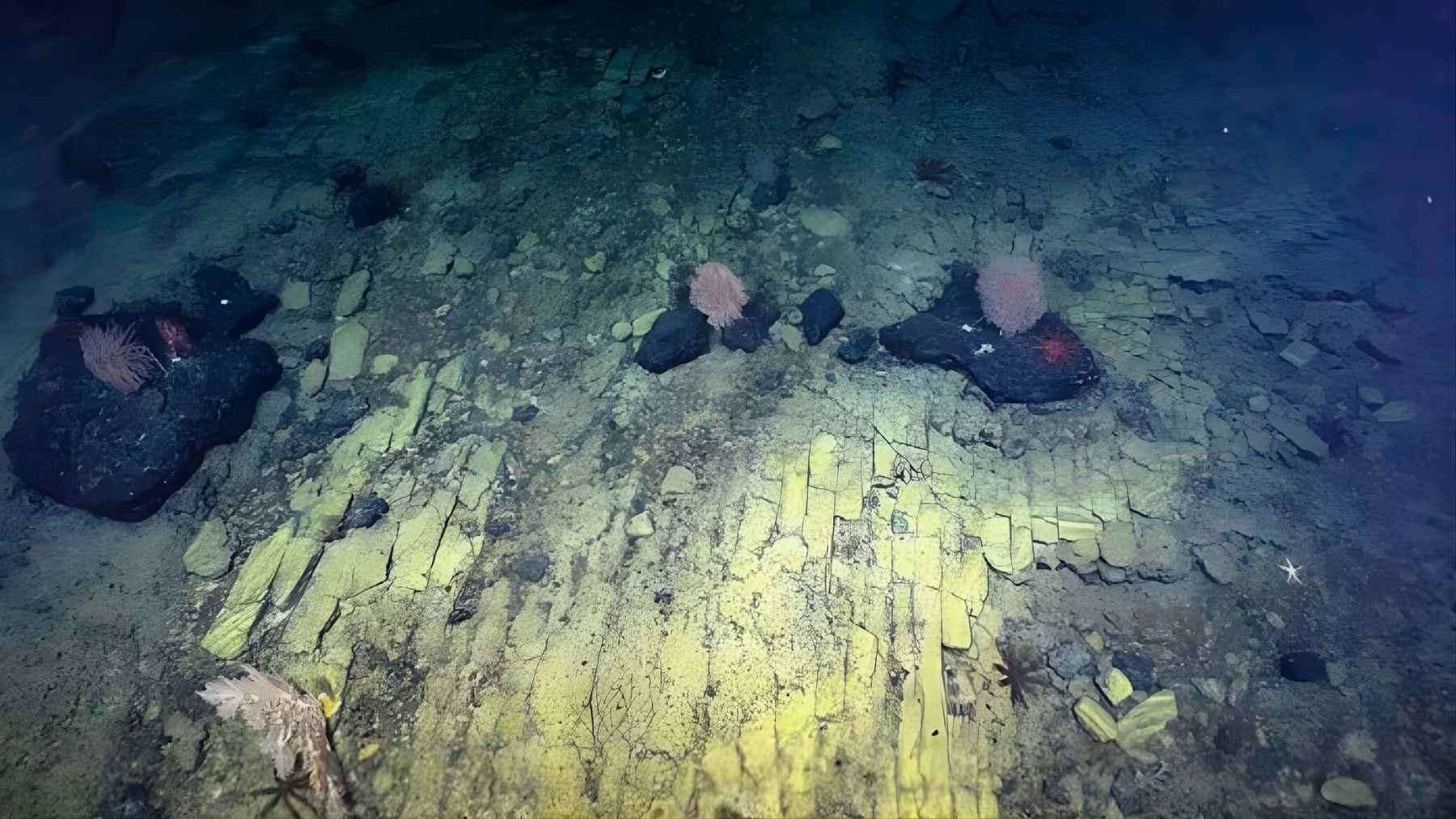
What the cameras really found
The road is not a lost city. It is geology doing a very good impression of urban planning.
According to the Ocean Exploration Trust team, the tiles are actually a fractured flow of hyaloclastite, a volcanic rock that forms when hot lava meets cold seawater during energetic eruptions and then settles on the seabed. Over time, heating and cooling stress broke the rock into sharp ninety degree cracks, creating a natural mosaic that looks like carefully placed bricks.

In other words, no ancient engineers, just physics and time. Yet the result is so striking that Nautilus described it with a wink, noting that what appears to be a yellow brick road to a mythical city is in fact an example of ancient active volcanic geology.
A surreal landmark in one of Earth’s biggest protected areas
This particular seamount lies within Papahānaumokuākea Marine National Monument, a protected region that covers about 582,578 square miles of the Pacific Ocean. That is larger than all United States national parks combined and makes Papahānaumokuākea one of the largest marine conservation areas on the planet.
During the Luʻuaeaahikiikekumu expedition, Nautilus completed 11 remotely operated vehicle dives between roughly 700 and 3,500 meters depth, mapped more than 28,000 square kilometers of seafloor and collected nearly 600 pounds of rock along with many biological samples. These data help scientists decipher how the chain of ancient volcanoes formed and how deep sea corals, sponges and microbes make a living on their rocky slopes.
The yellow brick road scene is only one highlight among many, yet it stands out because it makes a very alien environment feel suddenly familiar. It is the kind of image that sticks in your mind long after you close the browser tab.
A tiny glimpse of a largely unseen world
Here is the bigger twist. Even with viral moments like this, humanity has barely begun to see the deep seafloor at all.
A 2025 analysis led by researchers from the Ocean Discovery League, Scripps Institution of Oceanography and Boston University pulled together records from more than 43,000 deep sea dives carried out since the late 1950s. Their conclusion was stark. The deep ocean, defined as waters 200 meters or deeper, covers about 66 percent of Earth, yet less than 0.001 percent of the deep seafloor has been visually observed by cameras.
That fraction corresponds to an area roughly similar to the size of Rhode Island or about a tenth of Belgium. Everything else remains unseen, at least in terms of direct video or photographic coverage.
So while the yellow brick road clip has circulated widely on social media, it represents only a pinprick in a vast, unmapped wilderness.
Why the deep ocean matters for climate and life
It might be tempting to think of that wilderness as distant and irrelevant to daily life. After all, it is hard to picture a seamount while you are looking at your smartphone or checking the electric bill.
The deep ocean, however, plays a central role in keeping the planet habitable. The Science Advances study notes that deep waters help regulate climate by absorbing most of the excess heat and a substantial share of the carbon dioxide created by human activities. These regions also support enormous biodiversity, from microbial communities inside mineral crusts to corals, fishes and invertebrates that have never been named.
At the same time, scientists warn that pressures on the deep sea are rising, including climate driven changes, pollution and interest in seabed mining. Without baseline information about what is down there, decision makers risk damaging ecosystems that we barely understand.
Why a viral “road” matters for conservation
This is where missions like the Nautilus dives around Liliʻuokalani Ridge play an outsized role. The expedition not only gathered geological and biological samples, it also streamed 4K video to anyone with an internet connection, and hosted dozens of live ship-to-shore conversations in Hawaiian, English and American Sign Language.
Moments such as the yellow brick road encounter turn abstract statistics into something people can see. A crackled sheet of volcanic rock suddenly becomes a symbol of both Earth’s creativity and our ignorance of its deepest places. That connection can inspire public support for protecting areas like Papahānaumokuākea and for investing in exploration that includes local and Indigenous voices.
In practical terms, every mapped ridge and every documented community of sponges or corals helps managers decide where human activities should be restricted and where they might be allowed with caution. The more we see, the better chance we have of avoiding irreversible harm.
The path on the seafloor may not lead to Oz, but it does point toward a future where the deep ocean is less of a mystery and more of a shared responsibility.
The study that estimated how little of the deep seafloor has been visually explored was published in Science Advances.
Images credit: E/V Nautilus