In just a few weeks, three winter storms named Kristin, Leonardo and Marta have soaked Spain and Portugal so heavily that the damage can now be seen from space.
New images from the European Space Agency Copernicus Sentinel-1 mission show major flooding along Portugal’s Tagus River basin after parts of the Iberian Peninsula received more than 250 millimeters of rain in seven days.
In Spain, Andalucia and Galicia have endured repeated downpours, while the mountain region around Grazalema in Cádiz recorded more than 500 millimeters of rain in 24 hours.
In Portugal, towns along the Tagus basin including Alcacer do Sal have faced swollen rivers and flooded fields, prompting a state of calamity in 69 municipalities. So what does that look like when you zoom in from orbit?
Why Sentinel-1 radar matters in a storm
From orbit, the story looks stark. Sentinel-1 uses synthetic aperture radar, which can see through thick clouds and does not depend on daylight, a crucial advantage when skies stay gray for days on end.
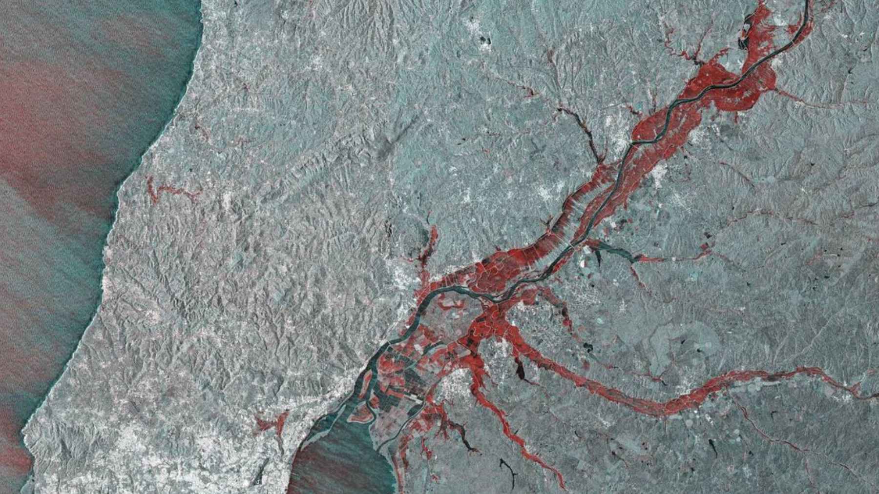
By comparing images from December 27 2025 and February 7 2026, ESA analysts highlighted in red the areas where water levels rose around the Tagus basin northeast of Lisbon, creating a clear before-and-after picture of the floodplain.
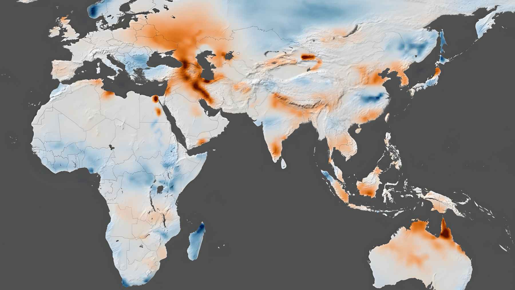
Alongside the radar view, ESA shared a rainfall map built with data from the Global Precipitation Measurement mission, a network of satellites led by NASA and JAXA. The map shows large swaths of Iberia shaded in red, meaning more than 250 millimeters of rain between February 1 and 7. Together, these datasets link the intensity of the rain to the true footprint of the floods.

Emergency mapping and the bigger climate signal
For emergency managers, this kind of space-based overview is more than a pretty graphic on social media.
The Copernicus Emergency Management Service was activated in late January for flooding in Spain and again in early February for Portugal, supplying rapid mapping products that help civil protection teams plan evacuations, check which roads are cut and coordinate flood defenses on the ground.
There is a wider climate context too. Scientists with the Intergovernmental Panel on Climate Change report that a warmer atmosphere can hold roughly 7% more water vapor per degree of warming and that heavy rainfall events have already become more frequent in many regions as the global water cycle speeds up.
Is climate change to blame for every drop of rain here? Not exactly, but to a large extent it fits the pattern of more intense wet extremes that experts have been warning about for years.
For people on the ground, the science may feel distant when you are refreshing a river level chart on your phone or wondering whether your usual route to work will be passable in the morning.
Yet the same satellites that track shrinking ice sheets and rising seas are now helping local authorities in Iberia respond faster to floods in real time, protecting homes, farmland and key infrastructure.
The official ESA press release was published on esa.int.