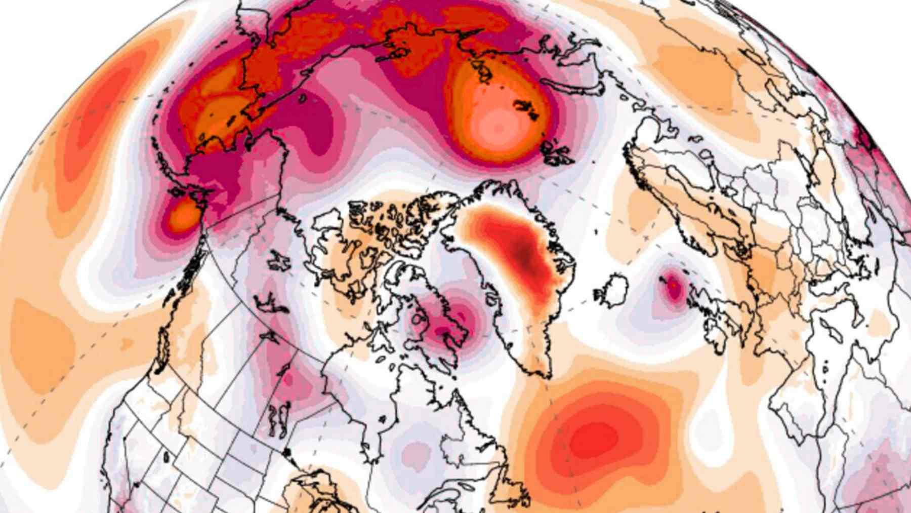
The warning did not arrive with blizzards or broken power lines. It first appeared as twisted streaks of color on high-altitude weather maps, showing a belt of icy air over the Arctic stretching and speeding up in ways veteran forecasters struggled to match with past winters.
For most of us, winter still feels familiar enough. Sidewalks are damp, jackets are light, and the heating bill is only starting to climb. Yet more than thirty kilometers above our heads, a rare polar vortex anomaly is unfolding faster than anything many climate scientists have seen in decades of winter data.
What the polar vortex is and why this one looks so different
The polar vortex is a giant whirl of very cold air that circles the poles high in the stratosphere, roughly between fifteen and fifty kilometers above Earth. The National Weather Service describes it as a broad area of low pressure and frigid air that usually keeps Arctic cold locked near the pole like a fence around a deep freezer.
Most winters that vortex strengthens and weakens slowly as seasons shift while waves of energy ripple up from lower levels of the atmosphere. A sudden stratospheric warming is a rapid jump in temperature high over the pole that can weaken the vortex.
This season, data from forecast centers in Europe and North America show an early event in late November that lifted temperatures near ten hectopascals by about thirty to forty degrees Celsius above normal while winds there slowed to a standstill and the vortex stretched into off-center lobes instead of a neat ring over the pole.
From strange maps to real-world impacts
You will not feel those stratospheric winds on your face when you step outside. What you do feel is the result when a weakened or displaced vortex allows tongues of Arctic air to spill south, bending the jet stream into deeper curves and slowing weather systems overhead.
Forecasts now suggest that the disrupted vortex could send repeated waves of cold air into parts of North America, Europe, and Asia during the coming weeks. Instead of one big cold blast and then a clean reset, meteorologists are watching for a pattern of sharp freezes followed by brief thaws and then new plunges, the kind of back and forth that recent research calls “weather whiplash“.
Scientists such as Jennifer Francis at Woodwell Climate Research Center have shown that these rapid swings between persistent regimes can damage crops, strain infrastructure, and make planning much harder for cities and businesses. For people on the ground, that might look like snow that melts into slush, refreezes into ice, and then gets buried under a new storm before roads, roofs, and budgets have fully recovered.
How to live with winters that keep changing the rules
So what can you actually do with the news that a polar vortex anomaly is on the way? One practical step is to stop thinking of the season as one smooth story and start thinking in ten- to fourteen-day risk windows, since the surface impacts of sudden stratospheric warming events usually unfold over that time scale and can arrive earlier or last longer than usual.
That means checking a trusted national or local forecast once or twice a week, not just glancing at a phone app before heading out the door. If you see a clear signal for a significant cold spell in the coming week, that is the moment to protect pipes, check heating systems, adjust travel plans, and make sure vulnerable family members or neighbors will not be caught off guard.
These preparations do not need to be dramatic. A small stash of shelf stable food, a couple of extra blankets, charged power banks, and a plan for remote work or school during the worst days can turn a dangerous cold surge into a difficult but manageable stretch.
In a world where winter patterns are more erratic, these habits are less about fear and more about basic resilience.
The official monitoring and analysis of sudden stratospheric warming events has been published on NOAA’s Climate Prediction Center website.