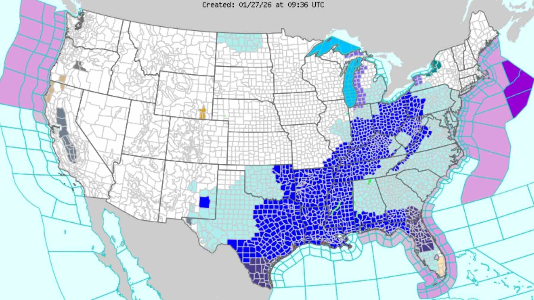
Millions of people from Texas to New England are still shoveling out after a historic winter storm that knocked out power to more than 800,000 customers and toppled snowfall records in parts of the country. Snow and ice brought travel to a standstill while bitter Arctic air pushed wind chills far below freezing. Now forecasters are watching the atmosphere reload for a second hit later this week that could target Washington DC and the broader East Coast.
The National Weather Service already flags “well below normal temperatures” across the eastern half of the Lower 48 and warns of an “increasing potential of another significant winter storm to impact the eastern United States this coming weekend”.
An Arctic high pressure system behind the current storm is expected to keep dangerously cold air locked in place while new upper level energy dips south from Canada and taps Gulf of Mexico moisture. That setup can turn frigid air into heavy snow or ice for a wide zone from the southern Plains to the Mid Atlantic and Northeast, depending on how the storm develops.
Meteorologists are also watching the larger pattern that shapes the storm track. FOX Weather highlights an “atmospheric traffic jam over Greenland” combined with a strong ridge over the Intermountain West. Together, these features tend to steer systems along the East Coast and keep cold air funneling toward the Interstate 95 corridor.
Some European and AI assisted models lean toward a more impactful coastal storm for the Mid Atlantic, while the American GFS model has so far been less aggressive. The Weather Prediction Center notes that guidance now shows a stronger signal for a weekend coastal low but stresses that the interaction of northern and southern stream energy, and therefore the exact track, is still “far from settled.”
So what does one more snow threat have to do with the environment and climate
On a warming planet, cold waves still happen, but they play out in a moister atmosphere. Scientific assessments find that heavy precipitation events are already becoming more frequent and more intense as warmer air holds more water vapor. In the United States, the biggest jump has been in the Northeast, where extreme rain and snow days have increased by about sixty percent since the 1950s according to the Fifth National Climate Assessment.
That does not mean this one storm is “caused” by climate change, but it does mean the dice are increasingly loaded toward wetter, more disruptive systems when cold air is in place.
For communities, another storm on the heels of a “historic” one is about much more than pretty snow photos. Power grids already strained by ice and record demand for heating may face renewed stress. Prolonged snow cover can worsen radiational cooling at night, keeping temperatures low and heating bills high for families who are already feeling this cold snap through drafty windows and long commutes on icy roads.
At the same time, rapid melt after back to back storms can overwhelm storm drains and creeks, especially in Appalachian and Mid Atlantic valleys that are already seeing more intense downpours.
In practical terms, residents along the eastern seaboard now face a familiar checklist. Follow local National Weather Service updates, limit non essential travel if snow or ice materialize, clear gutters and storm drains where it is safe to do so, and check on neighbors who may struggle with the cold. Whether this weekend’s system becomes a major coastal storm or slides offshore, the pattern is a reminder that winter extremes, energy use and climate trends are now tightly intertwined.
The official forecast discussion was published on NOAA’s Weather Prediction Center.