Satellites from NASA have captured active wildfires burning across snowy, frozen landscapes near the top of the world.
The scenes, described by researchers as “fire in the ice,” appear in a new assessment from the Arctic Monitoring and Assessment Programme, a working group of the Arctic Council that relies heavily on NASA data. For a region many people picture as solid white, those orange burn scars are a stark warning that the Arctic is changing fast.
The report concludes that the Arctic is now warming roughly four times faster than the global average, drying out soils and reshaping snowfall and rainfall patterns in ways that make the land far easier to ignite.
When lightning hits exposed vegetation in this new climate, fires can burn hotter and longer than these ecosystems are used to. At the end of the day, what happens around the pole will influence climate, air quality, and even weather far from the ice.
Satellites capture “fire in the ice”
In recent years, Earth observing satellites such as Landsat and the MODIS instruments on the Terra and Aqua spacecraft have watched fire detections creep steadily northward.
Maps made by the NASA Earth Observatory comparing data from 2002 to 2012 with detections from 2012 to 2024 show more fires overall and a clear shift toward higher latitudes. What once looked like isolated sparks at the very edge of the Arctic is turning into a wide band of burning across the far north.
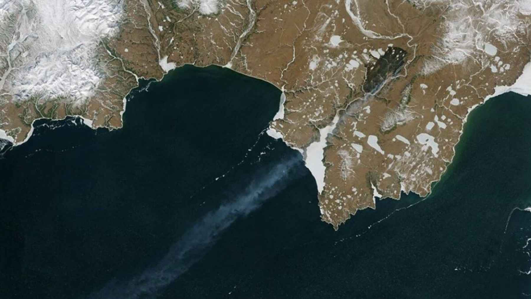
One striking satellite image shows a plume of smoke rising between frozen ground and ice-covered water. For researchers, that kind of picture is more than a dramatic view from space, since each pixel can be matched to fire records, air quality measurements, and ground surveys.
Over time, that detailed record lets scientists tell the difference between one unusual summer and a genuine long-term shift.
“Fire has always been a part of boreal and Arctic landscapes,” explained Jessica McCarty, Deputy Earth Science Division Chief at NASA Ames Research Center and lead author of the new assessment. Her team finds that, for the most part, recent Arctic fires now resemble the extreme events more familiar from temperate or tropical forests.
That means more days with thick smoke, tougher conditions for firefighters, and a growing burden on communities that never expected flames to reach so far north.
A warming Arctic becomes easier to ignite
According to the 2025 findings, the North American Arctic now sees roughly twice as much land burned each year on average as it did in the mid-20th century. Brendan Rogers, a senior scientist at Woodwell Climate Research Center who contributed to the work, notes that this shows up when you stack together many decades of data rather than only counting headline-making years.
In practical terms, that means more forests, shrublands, and tundra patches scorched in summers that feel longer, drier, and more unstable.
The physical drivers are familiar to climate scientists but increasingly visible to anyone watching northern weather. Warmer air can shift where and when snow and rain fall, while also drying soils and vegetation when heat waves and strong winds arrive.
Experts warn that this mix is leaving the far north more exposed to lightning and other triggers that turn a warm summer into a severe fire season.
Lightning now plays a central role in this story. The Arctic fire assessment finds that strikes are reaching farther north, providing the spark that can turn a patch of dry tundra into a fast-moving blaze. On a satellite map it may appear as a tiny red dot, yet on the ground it can mean miles of burning land and smoke drifting into towns hundreds of miles away.

Deep burns, hidden carbon, and global ripple effects
“It is the intensity that worries us the most,” warned Tatiana Loboda, chair of the Department of Geographical Sciences at University of Maryland. Lower-intensity fires may leave many trees standing and only scorch the upper soil layers, which gives the land a better chance to recover.
Very intense fires can strip away that protective cover, reshaping how water, snow, and even future vegetation move across the landscape.
When flames burn down into peat and permafrost, they tap into carbon that has been stored in frozen ground for thousands of years. Recent work in NOAA’s Arctic Report Card, led in part by Woodwell Climate researchers, shows that once wildfire emissions are counted, some tundra regions have already shifted from storing carbon to releasing it into the atmosphere. That feedback adds more greenhouse gases to the air, which can fuel further warming and, over time, even more “fire in the ice.”
For people living far from the Arctic, it can be tempting to see these images as distant curiosities. Yet smoke from high-latitude fires can drift thousands of miles, adding haze to summer skies, worsening the air you breathe, and even nudging up health risks that show up in hospital visits and, eventually, in insurance costs.
As McCarty noted in the NASA Earth Observatory feature on these trends, the next step is more targeted satellite missions and field campaigns so scientists can track this complex new fire landscape and understand how rapid changes near the pole ripple through the entire planet.
The main study has been published in the Arctic Monitoring and Assessment Programme report Arctic Climate Change Update 2024 Key Trends and Impacts.