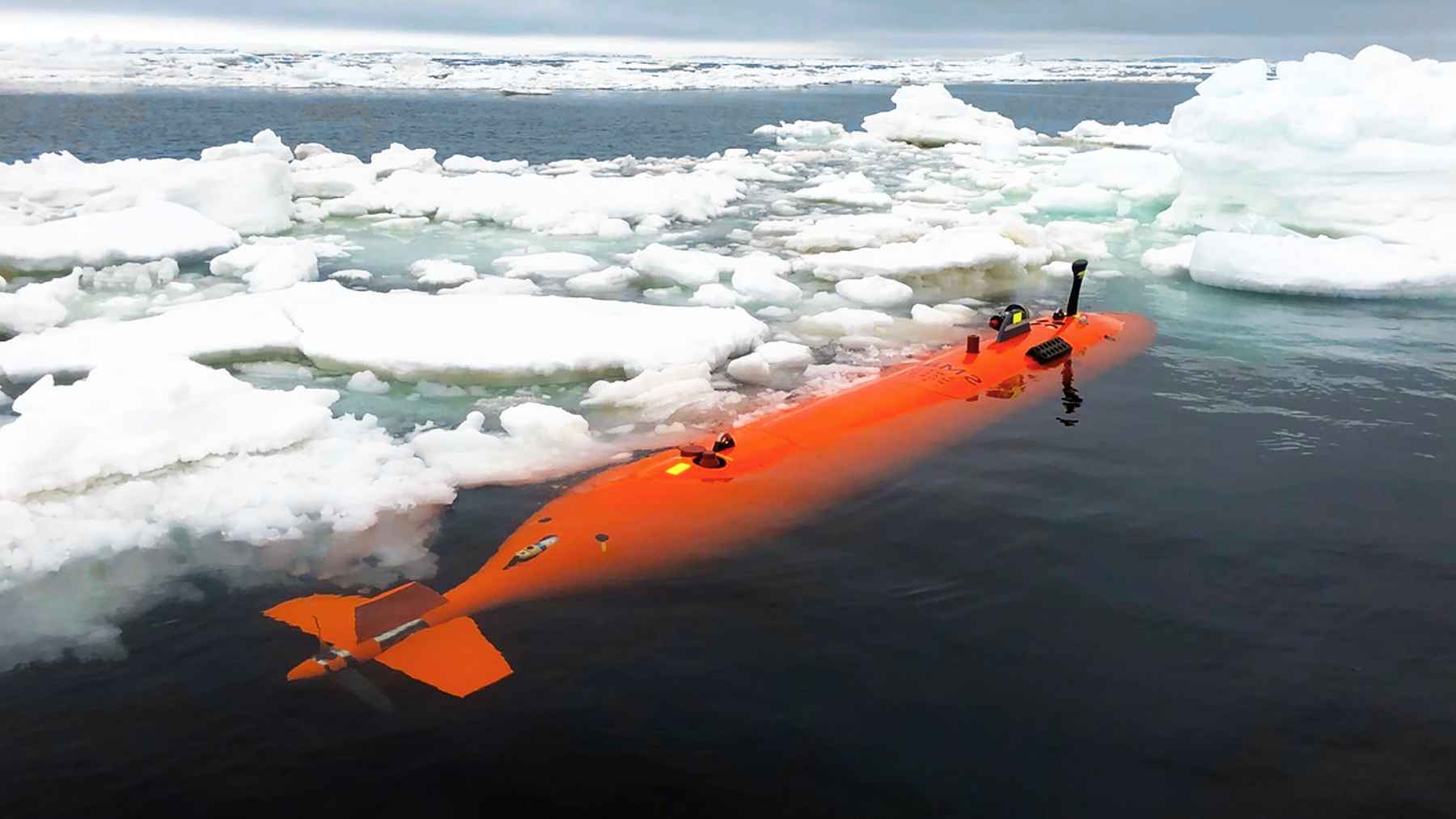
Germany has decided to buy eight MQ-9B SeaGuardian maritime drones, a U.S.-made system designed to watch huge stretches of ocean for long periods. The deal was backed by lawmakers in Berlin in mid December 2025 and formally announced on January 12, 2026, with first deliveries expected in 2028.
Why does this matter beyond Germany’s coastline? Because the purchase leans toward fast, proven gear from abroad at the exact moment Europe is trying to build its own shared drone and maritime patrol programs. If “defense sovereignty” means having European options ready when you need them, Germany’s move is a blunt reality check.
Berlin’s drone decision sits inside a much bigger spending surge
The German Bundestag’s Budget Committee approved the SeaGuardian purchase on December 17, 2025 as part of a package of defense contracts worth more than 50 billion euros, including about 1.5 billion euros for the drones to be bought through the NATO Support and Procurement Agency. The same bundle also covered air defense upgrades and a satellite surveillance system meant to support forces deployed to Lithuania.
The ministry described the approvals as “green light” decisions across dozens of procurement plans, ranging from cruise missile upgrades to new armored vehicle orders. In practical terms, it signals that Berlin is buying for the threats it sees now, not the ones that fit neatly into multinational schedules.
What SeaGuardian adds that Germany says it needs at sea
SeaGuardian is a remotely-piloted aircraft, meaning a crew flies it from the ground, not from inside the plane. The Bundeswehr says it can stay in the air for up to about 30 hours, using cameras, radar, and payloads that can release sonobuoys. Sonobuoys are floating sensors that listen for submarines under water.
The drones are meant to work alongside Germany’s P-8A Poseidon patrol aircraft, a U.S.-built jet used for maritime surveillance and submarine hunting. Germany first committed to five Poseidons in June 2021 and later expanded that plan, with Boeing saying deliveries would begin in 2025.
General Atomics Aeronautical Systems, the manufacturer, framed the deal as a way to share tools with allies using the same platform. Its CEO Linden Blue said, “The proliferation of MQ-9B in Europe delivers commonality,” and pointed directly to interoperability with Germany’s Poseidon fleet.
The awkward message for Eurodrone and the fading MAWS vision
Germany has been a key partner in Eurodrone, a European medium-altitude long-endurance drone program built by Airbus, Leonardo, and Dassault Aviation under the management of OCCAR. In October 2025, OCCAR said Eurodrone had completed a major design review and was moving into prototype production and ground testing ahead of a first flight.
That milestone matters, but Eurodrone is still in development, and maritime requirements can be unforgiving. A drone that is great for land surveillance may still fall short at sea if it cannot integrate smoothly with naval missions, rough weather, and submarine tracking.
Germany’s SeaGuardian choice also raises doubts about the Maritime Airborne Warfare System, a Franco-German concept meant to modernize airborne maritime awareness. NATO describes MAWS as part of a wider effort to align requirements for maritime patrol and submarine hunting, but Berlin is now committing to U.S. systems for both crewed and uncrewed roles.
Capability versus sovereignty in the Baltic and the North Atlantic
German defense planners point to the North Atlantic and the Baltic Sea as places where seeing far matters more than having the perfect industrial story. If undersea cables get cut or shipping lanes are threatened, the disruption can show up fast in daily life, from higher prices to patchy internet.
Supporters of the purchase argue that interoperability is the practical payoff. If partners are training with similar systems, data and tactics can travel faster when a crisis hits, and that is a hard advantage to ignore.
Critics, though, see a longer-term risk. Every big off-the-shelf buy can drain momentum from European projects that are supposed to deliver independence later. That tension is now out in the open.
The official press release was published on the General Atomics website.