Near the mouth of the Mississippi River, the levees finally end and the river goes back to doing what big rivers like to do: it slips through weak spots in its banks, cuts new channels into the marsh, and pours mud into shallow bays. These breaks, called crevasses, are creating new land in some of the fastest sinking parts of coastal Louisiana. At the same time, they are reshaping currents on one of the country’s busiest shipping routes and making it easier for salt water to creep toward people’s faucets.
So how do you let a river run a little wilder without putting drinking water and global grain shipments at risk?
A river that refuses to stay in its lane
Crevasses are not new. For thousands of years, the Mississippi wandered back and forth across its delta, dropping sand and silt that slowly built southeast Louisiana. Then came the 20th century, with high levees, rock walls, and deepened ship channels that locked the river in place to protect towns and keep cargo moving.

That control came at a high cost. Nearly 2,000 square miles of Louisiana wetlands have turned into open water since the 1930s, leaving coastal communities more exposed to storms and sea level rise.
Today, the few remaining gaps below the last levees are carrying a growing share of the river’s flow out into Breton Sound and nearby bays. Scientists call this “flow loss.” For shipping interests and water managers, it can look like a leak in the system. For coastal ecologists, it is one of the last natural pressure valves the delta still has.
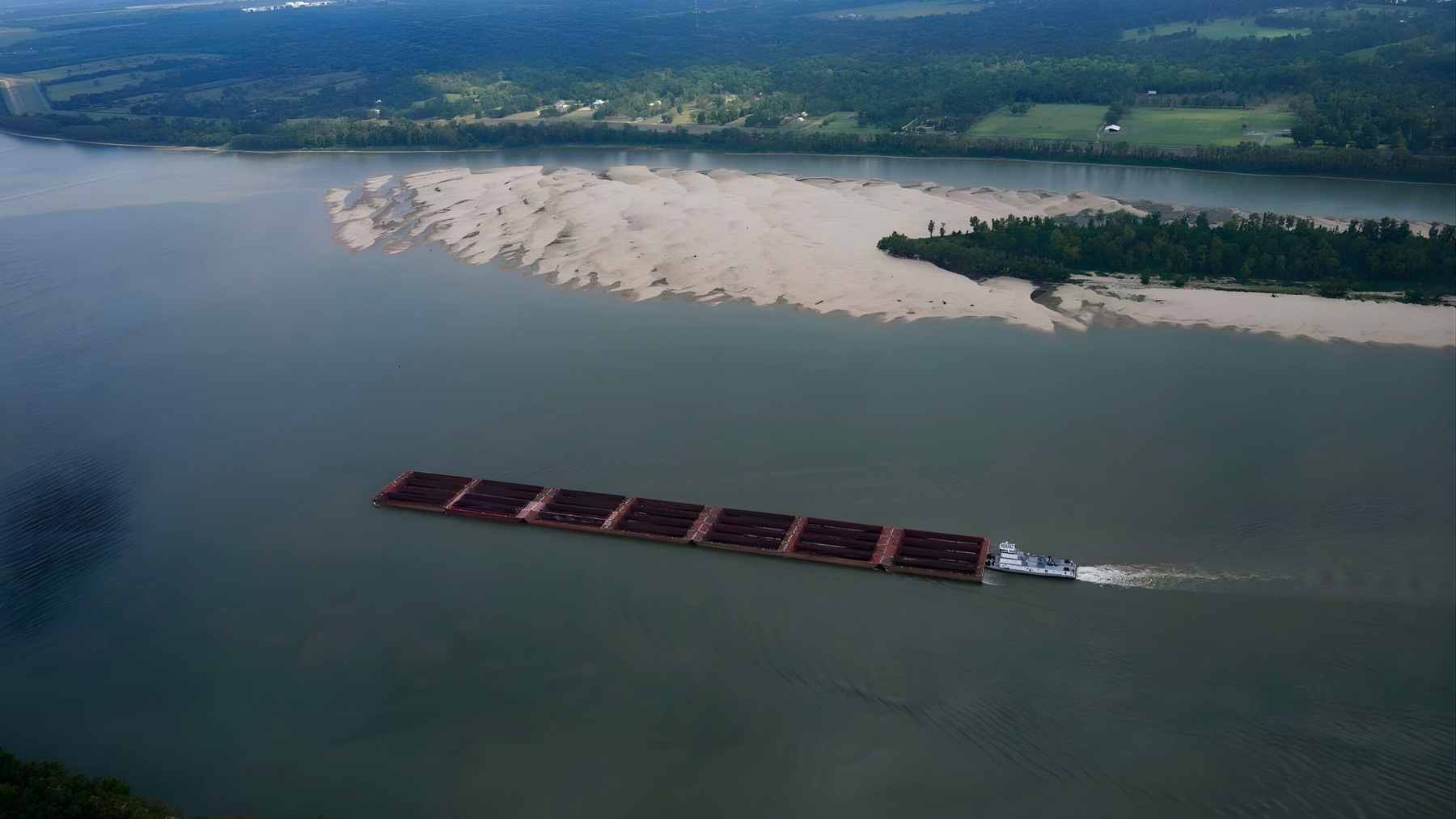
Neptune Pass shows what is at stake
The best known of these breaks is Neptune Pass, a crevasse on the east bank of the river across from the community of Buras. Once a narrow canal, it rapidly widened during high water between 2019 and 2021. Recent measurements show that Neptune Pass now carries roughly 15 to 17 percent of the Mississippi’s flow during moderately-high river stages, a volume comparable to a major stand‑alone river.
All that water and mud is building a new delta in Quarantine Bay. A peer-reviewed study published in 2025 found that the emerging delta is between 56 and 79 percent larger than the material scoured out of Neptune Pass itself. In simple terms, more sediment is arriving than was dug out, which means the system is a net land builder.
For a state that has lost about a quarter of its delta land area over the last century, seeing new islands rise in Quarantine Bay feels almost like watching time run backward.
When new channels meet old infrastructure
The same physics that make Neptune Pass a land-building machine also create headaches. As water peels off into side channels, the main river slows down, and sediment drops to the bottom, forming shoals that complicate navigation for deep draft vessels. Pilots worry about unexpected currents. Dredging bills climb.
There is another problem that shows up far from the marsh edge, right at the kitchen sink. When river levels are low, dense salt water from the Gulf pushes upstream along the bottom as a “saltwater wedge.” Recent drought years have allowed this wedge to travel dozens of miles inland, forcing emergency barge deliveries of fresh water and temporary treatment systems for communities in Plaquemines Parish.
If more flow escapes through crevasses while the main channel is carved deeper for ships, that wedge can move even faster toward the intake pipes that supply drinking water for hundreds of thousands of people.
At the same time, the Mississippi remains a backbone of global trade. Roughly 60 percent of all United States grain exports move down this river to ports near New Orleans and South Louisiana. Any change that slows barge traffic or interrupts the channel can ripple all the way to food prices in other countries.
The CREVASSE project tries to balance it all
Instead of simply closing every break, a new National Science Foundation funded effort wants to treat crevasses as a managed network. The initiative is officially called Coastal Resilience through Effective Versatile Adaptation and Sediment Strategies for Sea‑Level Rise Engagement, or CREVASSE. It brings together The Water Institute in Baton Rouge, the University of New Orleans, Nunez Community College, and the California Institute of Technology.
Researchers and engineers involved in CREVASSE plan to map how water and sediment move through natural and human-made cuts in the lower river, then test practical ways to guide that flow.
Ideas on the table include terrace structures in bays to trap mud, rock sills that restrict but do not fully shut off crevasses, and temporary sand dams that block a cut during low water but wash out when the river rises again. The goal is not a perfect, tidy river. It is a river that can keep feeding wetlands while still working as a shipping corridor and a reliable drinking water source.
A key part of the project happens far from computer models. Nunez Community College will develop training programs so local residents can build and maintain these nature-based structures, turning coastal restoration into stable jobs.
Shipping groups caution that unmanaged crevasses “will cause problems for both navigation and civilization,” as one industry representative recently put it. Coastal advocates counter that trying to seal every leak would only push the river to cut new paths somewhere else.
The science suggests both sides are partly right. The challenge now is finding a set of rules that lets the river help rebuild the delta without leaving ships stuck on sandbars or families hauling bottled water every month.
At the end of the day, what happens at places like Neptune Pass is about more than a remote bend in the river. It is about whether one of the world’s great working rivers can stay working in a hotter, stormier century.
The press release was published on Nunez Community College’s website.