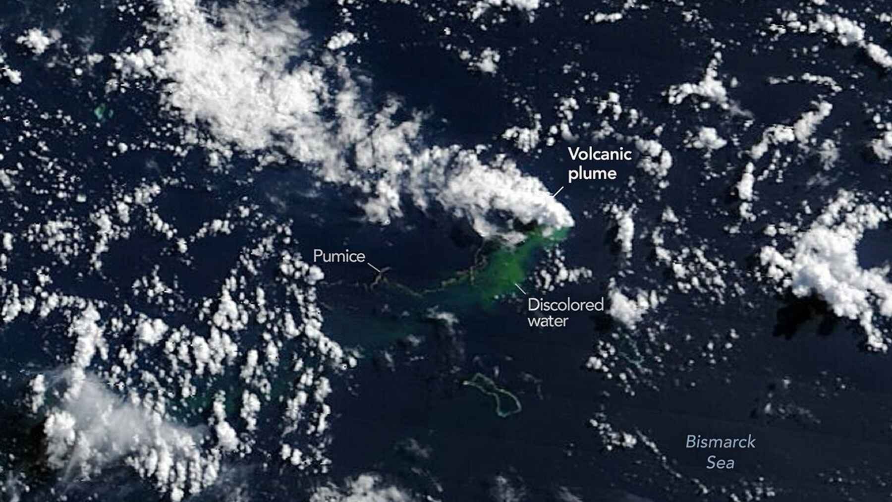
A powerful underwater eruption in the Bismarck Sea has given scientists a rare look at how new land can begin forming beneath the ocean. NASA satellites detected steam, volcanic ash, floating pumice, discolored water, and intense heat after the activity started north of Papua New Guinea on May 8, 2026.
For several weeks, the eruption appeared strong enough to raise an extraordinary possibility. If volcanic rock continued piling up in relatively shallow water, the hidden volcano could eventually break through the surface and create a new island. Activity has since weakened, however, so scientists are not claiming that a new piece of land is about to appear.
Warning signs beneath the water
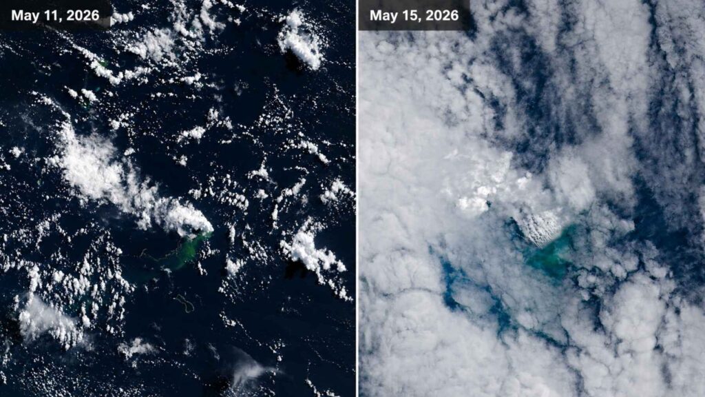
The first clear sign of trouble was a series of small earthquakes recorded on May 8. Soon afterward, NASA’s Terra and Aqua satellites observed steam-rich plumes rising above the central Bismarck Sea, while other instruments detected changes in ocean color around the eruption site.
Satellite images later revealed greenish water and broad areas covered by pumice, a lightweight volcanic rock filled with air pockets. Thermal instruments also identified unusually hot zones covering about 2.7 square miles, suggesting that magma or freshly erupted material had moved close to the ocean surface.
That heat was an important clue. Scientists could not directly see the vent beneath the water, but the combination of hot material, earthquakes, steam, and floating rock left little doubt that an eruption was underway.
The volcano remains a mystery
Here is the curious part. Researchers still cannot say with complete certainty which underwater volcano produced the eruption.
The region has not been mapped in enough detail to reveal every ridge, cone, and volcanic vent on the seafloor. The most likely source is a structure along Titan Ridge, an area shaped by intense tectonic activity roughly 10 miles southeast of another submarine eruption recorded in 1972.
It is a reminder that large parts of our own planet remain poorly explored. Scientists have detailed maps of the Moon and Mars, yet many areas beneath Earth’s oceans are still represented only by rough estimates. The water above them acts like a heavy curtain.
Could an island really appear?
Underwater volcanoes create new land when lava, ash, and broken rock accumulate around an erupting vent. If the eruption happens in deep water, that material may build a mountain on the seafloor without ever reaching the surface.
Shallower eruptions are different. When enough material piles up and the activity continues for long enough, the top of the volcano can rise above sea level. That is how some volcanic islands are born.
“We’re now eagerly waiting to see if a new island is about to be born,” NASA chief scientist Jim Garvin said while the eruption was still producing strong signals. At that stage, the large amount of heat and volcanic material made island formation a realistic scientific possibility.
Still, forming an island is only half the battle. Waves, storms, and erosion can quickly tear apart loose volcanic deposits. A young island may survive for years, disappear within months, or remain as a dangerous reef just below the waterline.
A process seen before
The Pacific Ocean has produced several examples of islands emerging during submarine eruptions. One of the best known is Hunga Tonga-Hunga Ha’apai, which grew between existing islands after an eruption that began in late 2014.
That new land lasted for years and gave scientists an unusual opportunity to watch erosion reshape a volcanic island. A much larger eruption in January 2022 later transformed the area almost completely and sent shock waves around the world.
Other volcanic islands have been far more temporary. Some were reduced to rocks and shoals almost as soon as waves began hitting them. So, even if the Bismarck Sea eruption eventually reaches the surface, there is no guarantee the resulting island would stay there.
Floating rock reached nearby islands
The eruption also affected people living well beyond the suspected vent. Large pumice rafts drifted toward the Admiralty Islands and accumulated near Lou, Baluan, and Manus.
One reported mass of floating pumice measured about 1.9 miles wide and 3.1 miles long, with sections estimated to be around 16 ft. thick. More than 10,000 residents in fishing communities were reportedly affected as the material blocked coastal waters and made boat travel more difficult.
For families who depend on the sea, this was not simply an interesting image from space. Thick pumice can interfere with fishing, damage boat engines, block access to markets, and make short trips between islands much harder.
That is where a distant geological event suddenly becomes part of everyday life.
Pumice can help and harm marine life
Pumice is filled with tiny holes created by volcanic gases, which allows much of it to float. Large eruptions can produce rafts that travel hundreds or even thousands of miles before sinking or washing ashore.
These floating rocks can carry algae, barnacles, small shellfish, and microorganisms across the ocean. In that sense, a pumice raft works like a fleet of tiny biological boats, helping some species reach new habitats.
However, the effects are not always positive. Thick layers of pumice may block sunlight from reaching seagrass or coral, scrape reefs, and harm marine animals that mistake small fragments for food. The same raft that transports life can also disrupt it.
Most volcanoes are hidden underwater
Smoking mountains and rivers of lava dominate our image of volcanoes, but most volcanic activity takes place far from human sight. NOAA estimates that about 75 percent of Earth’s volcanic activity occurs beneath the ocean.
Much of it happens along mid-ocean ridges, where tectonic plates move apart and magma rises to create new crust. Many of these eruptions occur more than 1.2 miles beneath the surface, where the enormous pressure changes the way lava and volcanic gases behave.
Underwater volcanic areas can also host hydrothermal vents. Seawater sinks through cracks, heats up near magma, and returns carrying minerals and chemical compounds.
No sunlight reaches these deep environments. Even so, microorganisms obtain energy from chemicals through a process called chemosynthesis, supporting crabs, worms, shellfish, and other animals in one of Earth’s most unusual ecosystems.
Satellites offer a view from above
Mapping the seafloor in high resolution normally requires ships equipped with sonar. These vessels send sound waves toward the bottom and measure how long the echoes take to return.
The method works well, but covering a large ocean basin is slow and expensive. A research ship must travel across the area in carefully planned lines, almost like mowing an enormous lawn.
Satellites cannot see directly through deep water, but they can detect what an eruption does to the surface. Heat, changes in water color, floating pumice, steam, ash, and newly exposed land can all be monitored from orbit.
In practical terms, that means researchers can follow a remote eruption almost in real time, even when they do not have a ship nearby or a detailed map of the volcano itself.
The eruption has become much quieter
The Rabaul Volcano Observatory later reported that activity had fallen to very low levels. From mid-June into early July, seismic activity was largely absent, underwater acoustic signals were limited, and only weak areas of discolored water remained near the eruption site.
A small steam emission was observed on July 2, indicating that the system had not necessarily shut down completely. However, the large pumice rafts had mostly separated into smaller patches, while fragments continued to collect along beaches and sheltered coastlines.
For now, no new island has been officially confirmed. The eruption could strengthen again, stay quiet, or continue changing the seafloor without ever becoming visible above the waves.
Whatever happens next, the event has already shown how much remains hidden beneath Earth’s oceans. A new island may not emerge this time, but satellites have allowed scientists to watch the planet rebuilding itself one plume, earthquake, and floating rock at a time.
The report was published on the Smithsonian Institution’s Global Volcanism Program’s website.