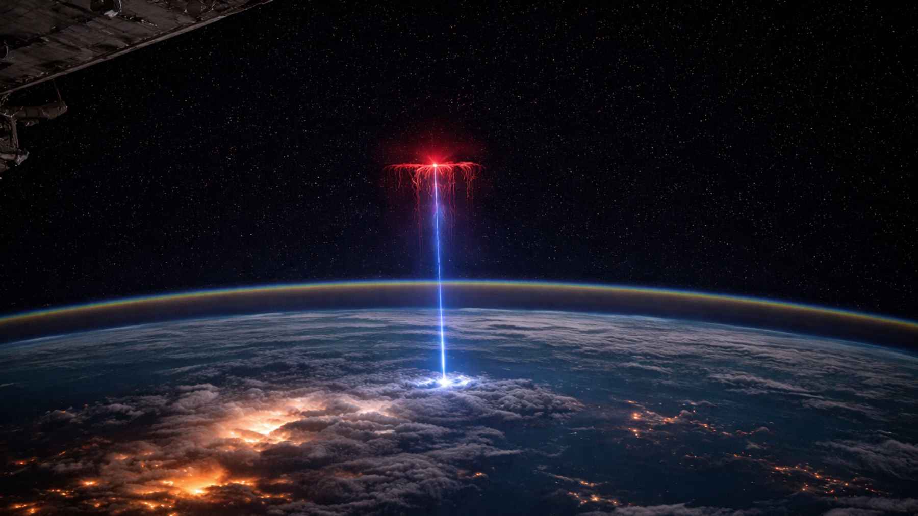
NASA is drawing fresh attention to a jaw dropping image from the International Space Station that shows lightning doing something most of us never see. Instead of striking down, this “gigantic jet” shoots upward from the top of a thunderstorm toward the edge of space.
It is easy to treat it like a one off spectacle, but scientists are watching closely for practical reasons. High altitude lightning can interact with the ionosphere, complicate aviation and spacecraft safety, and may influence upper atmosphere chemistry that feeds into weather and climate research.
A lightning show most of us never see
These bursts belong to a family called transient luminous events (TLEs), which includes red sprites, blue jets, and rapidly expanding rings of light known as ELVES. Pilots reported odd flashes for decades, but the first confirmed recordings only arrived in 1989, which is why this field still feels surprisingly young.
They can form far above storm clouds and last only milliseconds, so ground based observers often miss them entirely. From orbit, the view is cleaner, and the same storm systems can be revisited again and again until a rare event finally pops.
The gigantic jet that grabbed NASA’s attention
The image highlighted by NASA was taken on July 3, 2025 by astronaut Nichole Ayers, who first thought she had captured a sprite. NASA later confirmed it was an even rarer “gigantic jet,” a discharge that can escape a storm’s top and propagate upward toward space.
Gigantic jets matter scientifically because they connect atmospheric layers that are usually studied separately. NASA describes them as forming an electrical bridge between thundercloud tops around 12 miles (20 kilometers) and the upper atmosphere around 62 miles (100 kilometers), depositing a significant amount of charge along the way.
Why the space station is a sweet spot for storm science
From the ground, you are often looking through clouds at clouds, which is not ideal when the phenomenon happens above the storm. On the space station, instruments can watch storms from above, and NASA notes that these observations can improve atmospheric models used for weather and climate predictions.
A key piece of hardware is the European Space Agency’s Atmosphere Space Interactions Monitor (ASIM), installed outside the station’s Columbus laboratory since 2018. ESA lists ASIM’s mass at 314 kilograms (about 692 pounds), and notes the station’s speed during observations at 28,800 kilometers per hour (about 17,900 miles per hour), which helps show how much ground can be covered in a single night pass.
High speed cameras that slow lightning down
Not all the science comes from external instruments, either. The ESA backed Thor Davis experiment uses an event based Davis camera that senses changes in contrast, and ESA says it can capture the equivalent of 100,000 images per second while drawing only a few watts. (esa.int)
In one Thor Davis release, ESA astronaut Andreas Mogensen captured a red sprite above a thundercloud between roughly 25 and 50 miles (40 to 80 kilometers) above the ground. Scientists estimated the sprite’s size at about 9 by 16 miles (14 by 26 kilometers), and the project’s lead scientist Olivier Chanrion said, “The Davis camera works well and gives us the high temporal resolution necessary to capture the quick processes in the lightning.”
When storms poke the ionosphere and the radio layer
Some TLEs do more than glow, they can inject energy into the ionosphere, a charged region of the upper atmosphere that affects radio propagation. NASA explicitly warns that TLEs “can disrupt communication systems on the ground” and can “pose a threat to aircraft and spacecraft,” which is why building a large, well timed dataset is not just academic.
ASIM data has also helped confirm that lightning like discharges near storm tops can trigger ELVES, a massive ring shaped flash that expands in the upper atmosphere. NASA frames this as part of the wider connection between thunderstorms and space weather, a link researchers are still working to map in detail.
Invisible gamma flashes and messy atmospheric chemistry
Thunderstorms can also produce terrestrial gamma ray flashes (TGFs), which are brief bursts of high energy radiation. On the space station, the Light 1 CubeSat has carried detectors designed to observe TGFs, and NASA cautions that these events can expose aircraft systems and passengers to excessive radiation under the right conditions.
Then there is chemistry, and this is where the environmental implications get complicated fast. A major open access review in Atmospheric Research concluded that ELVES and halos likely have almost negligible global chemical impact, but sprites, blue jets, and impulsive corona discharges may contribute measurably to greenhouse relevant gases such as ozone and nitrous oxide, even though big uncertainties remain.
What comes next before the station retires
The trend line is clear even if the details are still being built out. More compact sensors and more small satellites can widen coverage, and NASA notes that small satellite detectors can cost less and be manufactured faster than some traditional approaches, which makes scaling up more realistic.
There is also a time limit to keep in mind. NASA says the United States, Japan, Canada, and ESA partner countries have committed to operating the station through 2030, which means today’s storm observations are helping set the baseline for whatever replaces the ISS era of “weather from above.”
At the end of the day, the message is simple. “The official statement was published on ‘NASA Science’.