El Niño winter outlook gives Florida and the coastal Carolinas a better than 70 percent chance of extra rain, and UCLA scientists say 2027 could set a new record for extreme downpours
El Niño winter outlook: NOAA gives Florida and the coastal Carolinas a 70%+ chance of extra rain, and UCLA says 2027 could set an extreme rain record.

· 4 min read
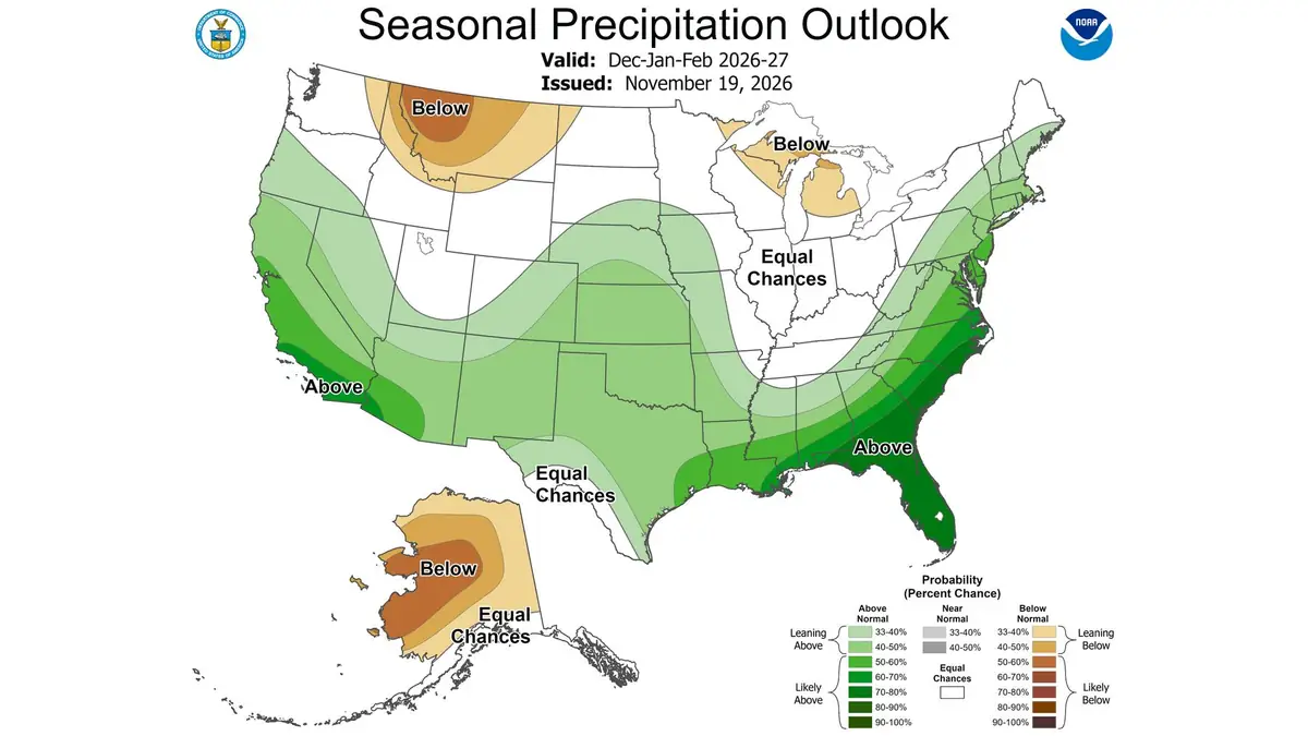
A strong El Niño is shaping up to make this winter wet across much of the southern United States. NOAA's seasonal outlook, issued November 19, gives Florida, southern Georgia and the coastal Carolinas a better than 70 percent chance of above-normal precipitation. NOAA also puts the odds at about 60 percent that this El Niño will beat every one on record since 1950. Meanwhile, UCLA researchers found that 2024 set a global record for extreme rainfall, with El Niño explaining only 20 percent of it and global warming tied to 40 percent. Alex Hall said, "We can't say that 2027 will break the 2024 record." But he added that the ingredients are lining up for another potentially exceptional year. NOAA stresses that even a very strong El Niño does not guarantee any single place will see its usual impacts.
Key points
- NOAA gives Florida, southern Georgia and the coastal Carolinas a better than 70% chance of a wetter winter
- About 60% odds this El Niño beats every event since 1950
- UCLA: 2024 set a global record for extreme rain, and 2027 could challenge it
The El Niño winter is shaping up wet for much of the southern United States. NOAA's Climate Prediction Center issued its seasonal outlook on November 19. It gives Florida, southern Georgia and the coastal Carolinas a better than 70 percent chance of above-normal precipitation this winter.
A day later, UCLA lined up its climate experts in a guide published November 20 by UCLA. The university says scientists monitoring El Niño this year project that it will be the strongest yet recorded.
Their topics range from flooding, both inland and on the coast, to damaged infrastructure and wildfires. Two of them, Alex Hall and Chad Thackeray, point to recent UCLA research that looks ahead to 2027.
What the winter map shows
The wetter-than-normal zone is wide. NOAA's outlook for December, January and February favors above-normal precipitation in southwestern Oregon, California, the Southwest and the central to southern Great Plains.
It also tilts the odds toward a wet season in the Southeast, the Mid-Atlantic and much of the Northeast. Below-normal precipitation is more likely in parts of the Great Lakes, the Northern High Plains, the Northern Rockies and mainland Alaska.
For temperature, the outlook favors a warmer than normal winter across much of the northern two-thirds of the Lower 48. The odds of above-normal temperatures top 50 percent in the Northeast, the Great Lakes, the Upper Mississippi Valley and the Pacific Northwest.

Parts of the Southeast are expected to stay near normal on average over the three months. The forecasters expect the strong El Niño to be the main influence on U.S. weather from this winter into next spring.
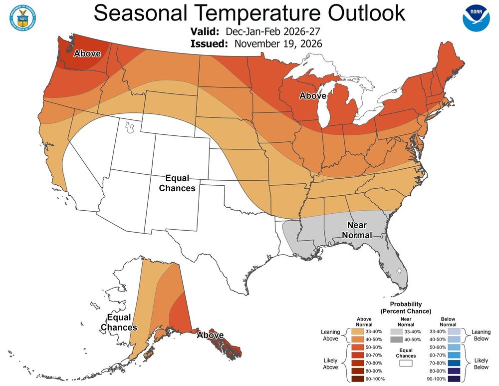
Forecast uncertainty is higher for the Southwest, the Southern Great Plains, the Gulf Coast and the Southeast. In the strong El Niños of 2023-24, 2015-16 and 1997-98, temperatures over the Southwest varied widely.
How strong this El Niño is
The numbers behind the forecast are unusual. NOAA's monthly El Niño update of November 12 put the key Niño-3.4 index at +2.5°C. Sea surface temperature anomalies topped 4.0°C in parts of the eastern equatorial Pacific.
Below the surface, the eastern Pacific was more than 10°C warmer than average at depth. The agency now gives better than even odds, about 60 percent, that this event will exceed every El Niño on record since 1950.
That threshold is a three-month value of +2.5°C or more on NOAA's Relative Oceanic Niño Index. For August to October, the index stood at +2.0°C, just shy of the +2.1°C reached in 1997.
In October, NOAA had already ranked the 2026 El Niño as the second strongest on record through August. The chance of a strong to very strong event lasting through January to March 2027 is now above 79 percent. The next update is due December 10.
Why 2027 could break records
UCLA's concern goes beyond this winter. In a study published October 9 in Science Advances, UCLA researchers found that 2024 set a global record for extreme rainfall. The occurrence of extreme precipitation ran 20 percent above the historical baseline.
That beat the strong El Niño years of 1983, 1998 and 2016. The team found that El Niño explained only 20 percent of the record, while global warming was tied to 40 percent.
Part of the rest came from a rare event. Large areas of the tropical Atlantic and Indian oceans were unusually warm at the same time as the Pacific. In 2024, the extreme rain even surged again in August, after the Pacific had cooled.
"The El Niño now developing is expected to peak this winter and could become one of the strongest on record," said Alex Hall, the study's senior author.
Hall, who directs UCLA's Center for Climate Science, stopped short of a prediction for 2027.
"We can't say that 2027 will break the 2024 record," Hall said. "But the ingredients are lining up for another potentially exceptional year for global precipitation extremes."
Lead author Chad Thackeray noted that the analysis relied on ocean temperatures from December to February. So the team does not yet know whether the warming in three oceans will repeat.
Floods now, fires later
UCLA's list of experts shows how many risks a wet El Niño winter brings. Hall can discuss how the rains can reduce wildfire risk now but may fuel fires later.
Water researcher Edith de Guzman studies how rain affects recent burn areas and how cities capture stormwater. Greg Pierce focuses on how cities prepare for flooding, including through Los Angeles County's Safe Clean Water Program.
On the coast, engineer Timu Gallien leads UCLA's Coastal Flood Lab and studies coastal flooding, erosion, energetic waves and sea-level rise. Political scientist Megan Mullin looks at disaster recovery, water storage and groundwater recharge.
No guarantees for any town
A strong El Niño loads the dice but does not decide the weather in any single place. NOAA notes that even with a very strong event, El Niño-like impacts are more likely, though not guaranteed.
The warm water is already changing parts of the California coast. Off central California, El Niño has turned Monterey Bay into a blue desert, with plankton crashing and humpback whales largely absent.
For the rest of the country, the next few months will show how much of NOAA's map comes true. For Florida and the coastal Carolinas, the odds of a soggy winter are the highest on the map.
Images: NOAA Climate Prediction Center
Glossary for this story
- El Niño
- A natural pattern in the tropical Pacific: El Niño warms its waters and La Niña cools them, and both shift weather around much of the world for months.
- NOAA
- The National Oceanic and Atmospheric Administration: the U.S. agency that tracks weather, climate, oceans and fisheries.
- Global warming
- The rise in the Earth’s average temperature since pre-industrial times, driven mainly by greenhouse gases from human activity.
- Sea level rise
- The rise in average ocean height caused by melting ice and by seawater expanding as it warms.
Jordi Company
Writer at ECOnewsJordi Company is a well-known figure in Catalan publishing and a pioneer of the free press model, with 40 years of experience in television, radio and print. He has founded and led several media groups and today heads ECOticias.com, an environmental news outlet read in Spanish and English around the world and an audience leader since 2004. He is a member of the International Network of Writers for the Earth (RIET), among other organisations.
More from Jordi CompanyComments · 0
Rules ›No comments yet. Be the first to share your view.