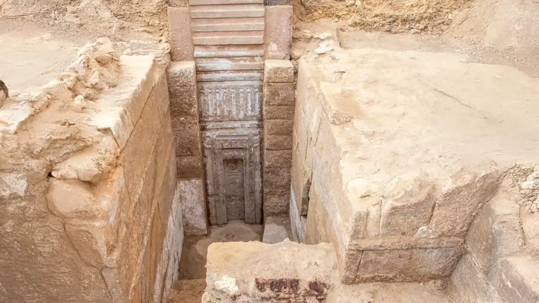
Archeologists in the Saqqara necropolis in Egypt have unearthed the tomb of Prince Waser-If-Re, and the door of the tomb is an even larger pink door that cannot be opened. It is an unusual kind of door to nowhere, the first material and scale to be found on the material in ancient Egypt. The tomb is that of a son of a king, Userkaf, who established the fifth dynasty of Egypt, and he lived around 4,400 years ago.
The false door plays an important role in the afterlife religion
Three feet wide, the massive false door of pink granite is covered with hieroglyphic elaborations that include Prince Waser-If-Re’s many titles, such as ‘Hereditary Prince,’ ‘Royal Scribe,’ ‘Vizier,’ ‘Judge,’ ‘Governor of Buto and Nekheb,’ and ‘Chanting Priest.’ Ancient Egyptians claimed that false doors were doorways in the spirit realm that could be used by the soul to transport itself between the world of the living and the afterlife.
The door cannot be opened as it was never intended as an actual door, but only as a symbolic one for the soul to pass through. This architectural feature reflects the advanced religious concepts of ancient Egyptians, for they tended to think of death as a transition instead of an end, and it was necessary to have a spiritual access point for the deceased to communicate with the living world.
This particular find is the first false door of such enormous size and made of pink granite found in ancient Egyptian archaeology, forming a new understanding of royal burials that took place during the Fifth Dynasty.
The tomb discloses a vast treasure of royal objects
In the tomb, archaeologists found 13 high-backed chairs with statues carved from a pink granite, which they believe to be images of the prince’s wives, with two heads missing. The team also discovered a toppled black granite statue that was over four feet long and a red granite table that was about three feet in diameter with inscribed letters describing ritual sacrifices.
The joint operation was carried out between the Supreme Council of Antiquities and the Zahi Hawass Foundation for Archaeological and Heritage under the care of famous archaeologist Zahi Hawass. Additionally, the tomb had a secondary entrance made of pink granite with the cartouche of King Neferirkare, indicating that the site was still important up to different dynasties.
Later dynasties used the ancient burial ground
Although the tomb was created during the Old Kingdom, long after that time, it was brought back into use during the 26th Dynasty, as was indicated by a black granite statue of a male figure more than four feet in height with a set of names and titles connecting it to that much later time.
One find does not hold archaeological significance as an end in itself
The dig also uncovered statues of King Djoser, his wife, and ten daughters, which Hawass thinks must once have stood in a chamber adjoining the king’s pyramid before he had them transferred to Prince Waser-If-Re’s tomb. This implies sophisticated mortuary practice with the movement of kingly objects through time.
The finding of Prince Waser-If-Re’s tomb with its pink granite door, impossible to open without the help of magic, changes the knowledge of ancient Egyptian funeral practices and beliefs. This false door, as a symbolic entrance and not an entrance, reveals the complex religious ideas about death and communicating with the afterlife. Its vast inventory of granite objects and the evidence for use over several dynasties suggests a royal tomb that few graves in Egypt have enjoyed, due to the huge amount of information these items can provide to archaeologists about royal burial rites through the centuries.