After several record-warm years, scientists are keeping a close eye on the tropical Pacific. New forecasts suggest El Niño, the warm phase that can nudge weather patterns, may return by early summer 2026.
Is a “super” El Niño locked in for July? Not necessarily. Still, new official outlooks leave room for an unusually strong event later in 2026, so the next few updates could reshape expectations fast.
Why the forecast is getting attention
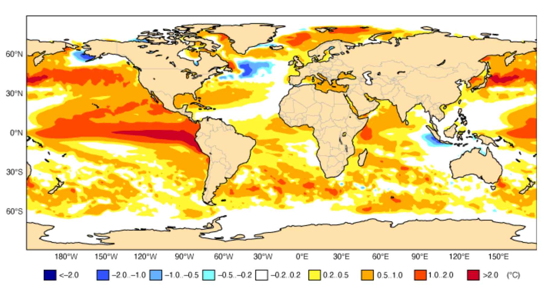
In an April 9, 2026 update, the National Oceanic and Atmospheric Administration’s Climate Prediction Center said the Pacific is neutral, but El Niño is “likely to emerge” in May through July, with a 61 percent chance. It also put the odds of “very strong” levels by winter at about one in four, hinging on whether equatorial winds keep pushing warm water east.
A March 11, 2026 explainer from Drought.gov described a similar split in the models, with about 80 percent crossing the El Niño threshold by early fall and roughly 20 percent staying neutral. It also made a simple point that matters, the ocean can look primed, but the atmosphere has to go along with it.
European seasonal forecast signals are also leaning warm, but the confidence is not sky-high yet. In a science blog post dated April 10, 2026, Tim Stockdale at the European Centre for Medium-Range Weather Forecasts said a moderate El Niño looks likely, a strong one is possible, and spring outlooks come with extra uncertainty.
What El Niño is, in plain terms
El Niño is part of a natural climate cycle called ENSO, short for El Niño and its cooler counterpart, La Niña. The key idea is that a patch of the tropical Pacific flips between warmer and cooler states, and the atmosphere reacts.
In normal years, trade winds push warm surface water toward Asia, while colder water wells up near South America. When those winds weaken, warm water can slosh back toward the Americas, raising ocean temperatures and shifting where tropical storms tend to form.
That shift can matter far from the Pacific because thunderstorms help drive the jet stream, a fast river of wind high above the ground. Move the storm engine, and the usual paths for storms and rainfall can bend with it.
When it becomes “super”
Not every El Niño is a blockbuster. One federal climate history page notes that events are often described as weak, moderate, strong, or “very strong” based on how far Pacific ocean temperatures rise above normal, and “very strong” starts around a 3.6 degrees Fahrenheit jump.
That “very strong” category is what many people mean when they say “super” El Niño, even though the label is not an official scientific class everywhere. Timing is also a big deal, because El Niño typically forms in summer and peaks months later, often around winter.
Forecasting is messier in spring because of a known blind spot sometimes called the “spring predictability barrier” in the tropical Pacific. The ENSO blog on climate.gov explains that the tropical Pacific often shifts gears in March through May, and that transition makes early predictions easier to miss.
What it could mean for US weather
El Niño’s fingerprints are not identical everywhere, but there are some patterns that show up often. An Ocean Service explainer says the Pacific jet stream can shift south during El Niño, leaving the northern United States and Canada warmer and drier than usual while the Gulf Coast and Southeast trend wetter, raising flood risk.
Hurricane season is another reason people pay attention, even if it is never a simple on-off switch. A climate.gov analysis says El Niño tends to suppress Atlantic hurricanes by increasing wind shear, meaning winds change with height and can tear storms apart, while it can favor more activity in parts of the Pacific.
Summer links are weaker than winter links, and uncertainty shows up in daily life, including that sticky summer heat and the electric bill that can follow. A 2020 research report on ENSO “teleconnections,” or long-distance climate links, found summer signals can be subtle, so day-to-day weather still drives heat waves, drought, and flooding.
Global ripple effects in a warmer world
El Niño is famous because its reach goes well beyond North America. A climate.gov overview of global impacts explains that by shifting jet streams and tropical rainfall, ENSO can tilt the odds toward drought in some regions and heavier rains in others, sometimes thousands of miles away from the Pacific.
The background climate now raises the stakes, and the numbers show why. NASA reported on January 14, 2026 that the planet’s average surface temperature in 2025 was about 2.14 degrees Fahrenheit above its mid-20th-century baseline, and 2024 remained the hottest year in its record.
El Niño adds heat on top of that baseline, which is why “record year” talk pops up when the Pacific warms. The World Meteorological Organization says recent years are near the Paris Agreement benchmark of about 2.7 degrees Fahrenheit of warming above preindustrial levels, meaning before industrial-era warming, so extremes can feel sharper even without a once-in-a-century event.
What to watch next
So what should people look for between now and the start of summer? A 2023 post on the climate.gov ENSO blog says forecasters will watch for bursts of westerly winds over the equatorial Pacific, since they can quickly strengthen a developing El Niño.
Another clue is consistency across different models and real-world measurements. When those line up in late May and June, confidence tends to rise, and the forecast becomes less of a guessing game.
For most people, the practical move is simple. Follow local heat and flood alerts, plan for swings, and remember that climate patterns load the dice, but they do not write your daily forecast.
The main official update has been published in the ENSO Diagnostic Discussion.