The tropical Pacific is starting to look restless again, and forecasters are paying close attention. El Niño, a recurring ocean pattern tied to floods, droughts, and heat, appears increasingly likely to develop later in 2026.
The latest U.S. outlook, issued April 9, 2026, puts the chance of El Niño forming during June to August 2026 at 62% and says it could persist through the end of 2026. It also highlights about a one in four chance the event reaches the “very strong” category, the zone where headlines start using the phrase “super El Niño.”
What El Niño is, in plain terms
El Niño happens when surface waters in parts of the tropical Pacific become warmer than usual. That warm water changes where heavy tropical rain tends to form, and the atmosphere responds like a set of dominoes falling one after another.
El Niño is part of a larger back-and-forth system called the El Niño Southern Oscillation (ENSO), which alternates with the cooler phase known as La Niña. On average, these events show up every two to seven years and often last about nine to 12 months, though they can sometimes linger longer.
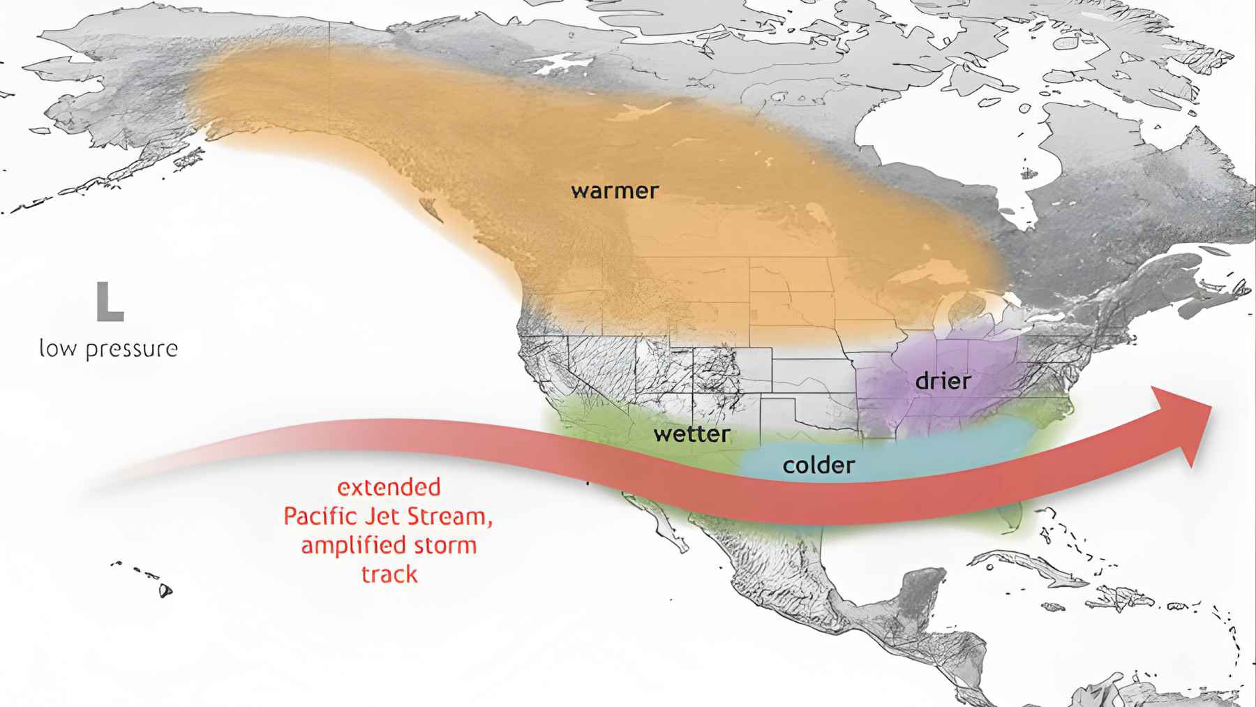
When the ocean and atmosphere lock into this pattern, it can tug the jet stream into a different position. That matters because the jet stream helps steer storms, and small shifts can tilt the odds toward wetter or drier conditions far from the Pacific.
What forecasters mean by a “super” El Niño
“Super El Niño” is an informal term, but it usually points to an El Niño that is unusually intense. In many discussions, it means sea surface temperatures in a key monitoring region rise at least 2 degrees Celsius, about 4 degrees Fahrenheit, above the long-term average.
These rare spikes are a big deal because intensity affects reach. A stronger El Niño can push the atmosphere harder and longer, making its fingerprints more noticeable across seasons.
A recent seasonal model run from the European Centre for Medium-Range Weather Forecasts, summarized by meteorologist Ben Noll of The Washington Post, suggested a 98 percent chance of at least a moderate El Niño by August 2026.
The same model run showed an 80 percent chance of a strong event and a 22 percent chance of a “super” outcome, numbers that are drawing plenty of attention.
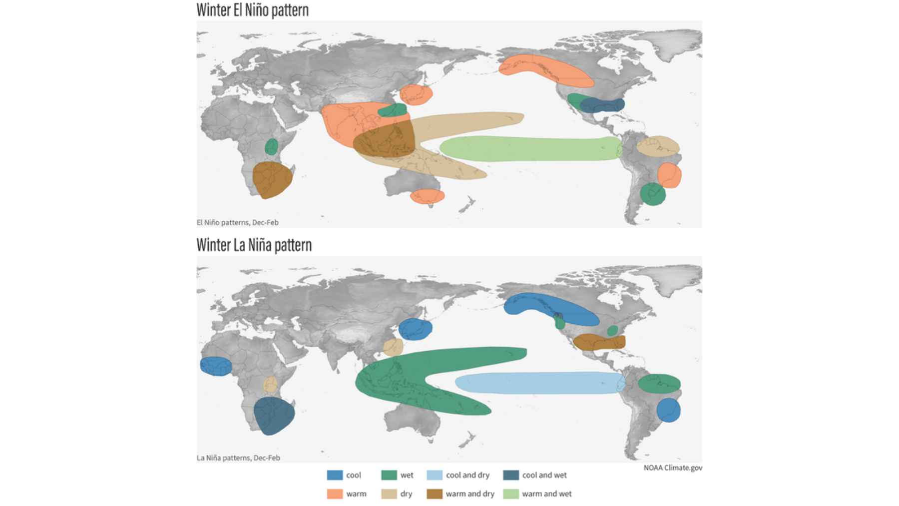
Global fingerprints: El Niño and La Niña represent opposite phases of a Pacific climate cycle that can trigger extreme weather thousands of miles away.
The odds for summer 2026 are rising, but uncertainty is real
Probability forecasts can feel slippery, especially when social media wants a yes or no answer. A 62 percent chance does not guarantee El Niño – it simply means it is the most likely outcome among several, based on current ocean and atmosphere signals.
The same outlook says neutral conditions are favored through April to June 2026, before the odds tilt toward El Niño as summer approaches. If this turns into a very strong event, forecasters say it will likely hinge on whether winds keep helping warm water spread and stay in place.
So what should you do with that? Treat it like a weather version of risk management, where a lower-probability path can still matter because the impacts could be large. Nothing is locked in yet.
Why the next few months matter for the forecast
There is a reason seasonal forecasts often come with extra caveats in spring. Models have a harder time predicting ENSO through this period, a well-known hurdle nicknamed the “spring predictability barrier.”
In plain language, the Pacific is switching gears, and small changes can swing the outcome. A short burst of favorable winds can help kick-start warming, while a slowdown can keep conditions closer to neutral.
International forecasters are weighing many models, not betting everything on a single set of numbers. A World Meteorological Organization seasonal update described a tight cluster of forecasts pushing toward El Niño conditions after April 2026, while also noting the spread tends to grow as spring unfolds.
What a stronger El Niño could mean for weather and everyday life
El Niño does not produce the same outcome everywhere, and it is rarely the only player on the field. Still, an official fact sheet explains that El Niño can shift the Pacific jet stream south, often leaving parts of the northern United States and Canada warmer and drier than usual while the Gulf Coast and Southeast trend wetter, which can raise flood risk in some seasons.
Outside the United States, the pattern can tilt odds toward drought in some regions and heavier rain in others, depending on the month and local geography. That matters for crops, water supplies, and shipping, and sometimes it shows up in everyday places like a grocery bill that spikes after a tough harvest.
Heat is another concern, especially if a strong El Niño stacks on top of an already warm background. More days of sticky summer weather can mean air conditioners running longer and higher electricity demand, even though scientists caution that no single storm or heat wave can be pinned on ENSO alone.
The main official outlook has been published by the National Weather Service’s Climate Prediction Center.