How small can a dinosaur be and still shake up what scientists think they know? A newly described fossil from northern Patagonia suggests that some of the strangest meat-eating dinosaurs were already tiny long before they evolved their most famous body features.
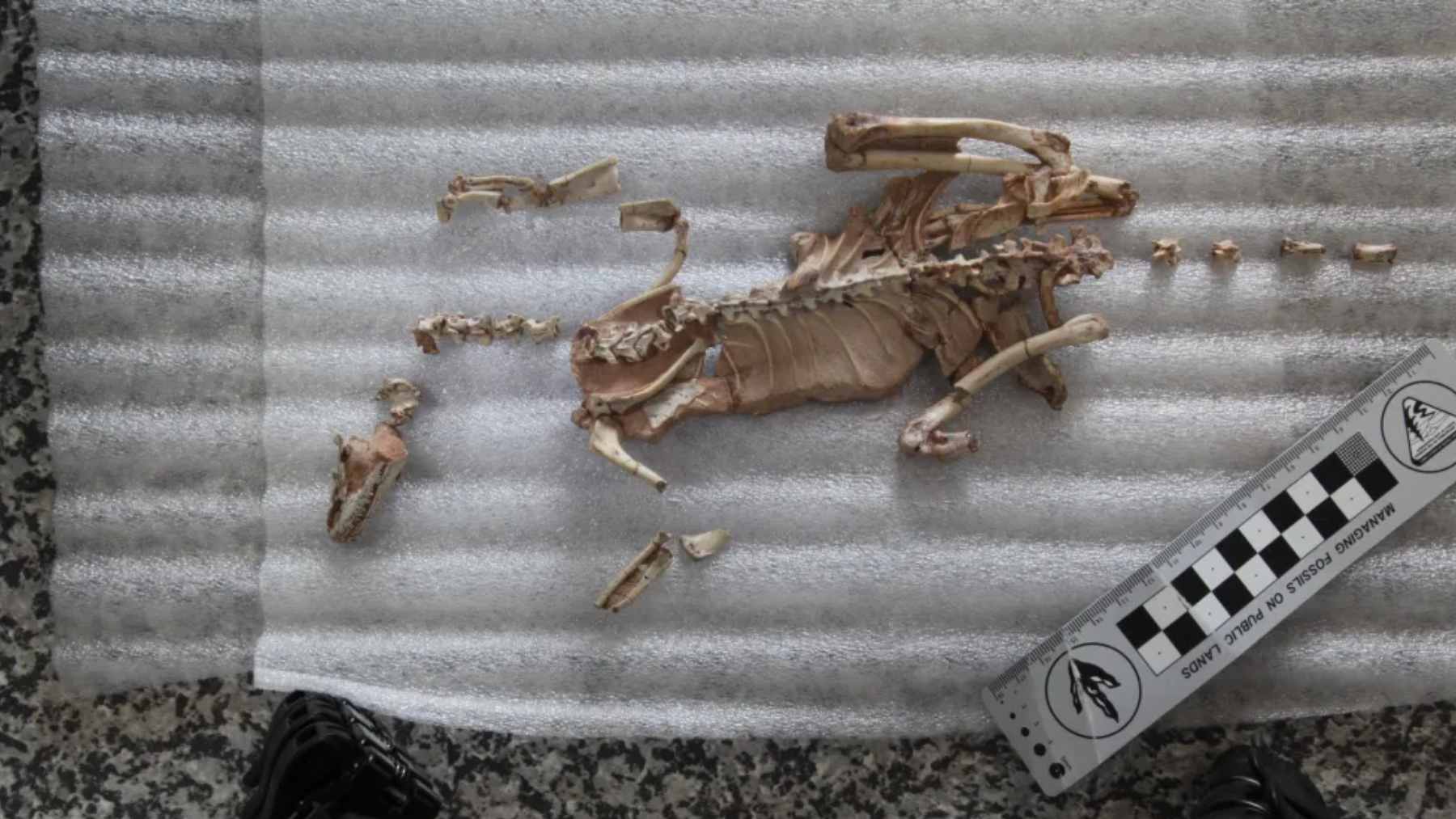
The animal is called Alnashetri cerropoliciensis, and it lived about 95 million years ago. Researchers say this near-complete skeleton helps connect scattered fossils across continents, turning a long-running debate about “alvarezsaurs” into a clearer story.
A crow-sized dinosaur from La Buitrera
The fossil was found at La Buitrera in Argentina’s Río Negro Province, a site known for preserving small animals from the Cretaceous, late in dinosaur history.
The dinosaur was about the size of a crow, roughly 28 inches long and around 1.5 pounds, and coauthor Sebastián Apesteguía of the Félix de Azara Foundation and Argentina’s National Scientific and Technical Research Council known as CONICET said it shows “it was not a time of giants, but rather a time of immense biodiversity.”
It was discovered in 2014 and spent years being carefully prepared, piece by piece, because the bones are thin and fragile. Many bones were preserved close to their life position, which hints that the body was buried quickly, likely under shifting sand.
This matters because most fossils of this group are incomplete, like getting a novel with half the pages missing. With a more complete body to compare, researchers can be more confident about what belongs where.
Meet the alvarezsaurs
Alvarezsaurs are theropods, the dinosaur group that includes famous predators and, eventually, modern birds. They are known for bird-like features, short arms that can end in a single oversized claw, and teeth that become very small in many later species.
For decades, the alvarezsaurs story looked lopsided. Many of the best fossils came from Asia, while finds in South America were often fragmentary, making it hard to tell whether the animals evolved in one place and spread, or were widespread early on.
Back in 2012, Alnashetri was first formally described from only a few leg bones from the same Patagonian region. That earlier description set the name, but it could not fully explain the animal’s place in the wider family tree.
A “Rosetta Stone” skeleton
The new study was co-led by the University of Minnesota Twin Cities, and the team describes the fossil as a “missing link” for a group that has been hard to pin down.
Paleontologist Peter Makovicky called the leap from scraps to a near-complete skeleton “like finding a paleontological Rosetta Stone,” and he said it gives researchers a much-needed reference point for identifying other partial fossils and tracking changes in body size and anatomy over time.

Scientists also looked closely at the bones themselves, using microscopic clues to estimate age. Those patterns suggested the animal was an adult at about four years old, which helps avoid mistaking youthful features for brand-new species.
In practical terms, that matters a lot. If you compare a teenage dog to a full-grown dog, you might think they are different breeds unless you know their ages.
Small first, specialized later
One of the clearest takeaways is that Alnashetri was small without being as “extreme” as its later relatives. It lacked some of the most reduced hand features seen in later alvarezsaurs, and its teeth were not as tiny, even though the animal was already petite.
That fits with the idea that very small body sizes may have evolved more than once within this lineage.
That pattern supports a simple idea. In this lineage, getting small seems to have happened before the full set of specialized traits, including the digging-style forelimbs and other changes often linked to feeding on social insects such as ants and termites.
Not everyone has agreed on how that shrinking happened. A 2021 Current Biology study argued that body size in alvarezsauroids, the broader branch that includes alvarezsaurs, dropped quickly between about 110 million and 85 million years ago, and that growth patterns varied across the group.
A world tour without ocean crossings
The team did not stop with Patagonia. By revisiting older fossils in museum collections from North America and Europe, they recognized additional alvarezsauroid specimens, which pushes the group’s reach beyond the places where it is usually discussed.
To explain that spread, the researchers point to Pangea, the ancient supercontinent that once connected much of Earth’s land. In the paper published February 25, 2026, they argue that as Pangea broke apart over tens of millions of years, populations could have been separated as the continents drifted, rather than needing unlikely ocean crossings.
It is a bit like tearing a big map into smaller pieces and watching each piece drift away. The animals did not have to cross the gaps that opened later, because the gaps were not there yet.
Why this tiny dinosaur matters now
Tiny fossils can end up doing outsized work in science. With a nearly complete skeleton, researchers can test old ideas about evolution that were built on scraps, and they can do it without guessing what is missing.
It also changes what a “dinosaur landscape” looks like in your head. If you picture only giants, you miss most of the action, and this find puts smaller hunters back into the scene.
Researchers plan to keep studying fossils from the same area, so this story may keep changing as new bones come to light. For now, Alnashetri is a reminder that big discoveries do not always come from big animals.
The main study has been published in Nature.