Far below the cold, rough waters of the Bering Sea, a hidden canyon drops deeper than the Grand Canyon. Zhemchug Canyon, a vast submarine valley between Alaska and Siberia, plunges about 8,530 feet from the shallow shelf toward the Aleutian Basin, while the Grand Canyon reaches about 6,000 feet at its deepest point.
That simple comparison sounds almost unreal. Yet the real story is not just size. This underwater gorge shapes currents, shelters deep-sea life, and reminds us how much of the ocean floor still sits beyond everyday human sight, like a landscape waiting in the dark.
The hidden giant
Zhemchug Canyon is not the kind of place anyone can stand beside with a camera. It lies beneath gray water, far from roads, railings, gift shops, and the familiar silence of desert cliffs.
Read More: {{post_title link:post}}
Research linked to the United States Geological Survey (USGS) describes Bering, Pribilof, and Zhemchug as three exceptionally large submarine canyons cutting into the southeastern Bering Sea slope. One classic Marine Geology study estimated Zhemchug’s volume at about 2,040 cubic miles, adding that it may be the world’s largest slope valley by that measure.
That is where the rankings get tricky. Some canyons are longer, and others may lead in total mapped area, but Zhemchug stands out for its huge cross-section and the amount of slope and shelf it has carved away. In practical terms, it is not just deep – it is enormous.
How a seafloor canyon formed
How does a canyon like this appear at the bottom of the sea? The answer, for the most part, reaches back into ice-age geography, when sea levels were lower and today’s drowned shelves were exposed or much shallower.
USGS researchers have linked the growth of Pribilof and Zhemchug canyons to Pleistocene conditions, when the Yukon and Kuskokwim rivers may have emptied into or near the heads of these undersea valleys. Later, sliding sediment masses and erosion helped cut and reshape the canyon system.
That makes Zhemchug feel less like a single crack and more like an old, restless route for moving sediment from land to deep ocean. The surface may look smooth from a ship, but below it, sliding sediment and erosion have scraped, breached, and rearranged the seafloor over immense stretches of time.
Life in the dark
It would be easy to imagine Zhemchug as a cold, empty trench. That would be wrong.
The eastern Bering Sea supports large populations of marine mammals and birds, along with some of the country’s most valuable commercial fisheries. The National Oceanic and Atmospheric Administration (NOAA) Fisheries notes that the canyons interrupt the continental slope several hundred miles from shore, creating complicated seafloor terrain where researchers have focused on corals, sponges, fish, and crabs.
Read More: {{post_title link:post}}
Deep-sea corals are not like the bright tropical reefs people picture on vacation. They grow in cold water beyond sunlight, filtering food from the water instead of relying on photosynthetic algae. Slow-growing and fragile, they can provide cover and structure for other animals, almost like an apartment building in a place that might otherwise be mud and gravel.
The green belt
Zhemchug sits within a much larger ocean story. Scientific research has described several immense eastern Bering Sea canyons as lying under the highly productive “green belt” along the continental slope.
That phrase matters. The “green belt” refers to a productive shelf-slope region where physical ocean processes can help bring nutrients into waters that feed plankton, fish, seabirds, and marine mammals. It is not exactly the kind of green you see in a forest, but in ocean terms, it is the base of a food web.
For anyone thinking about dinner plates, docks, or fishing towns, this is not abstract science. Pacific cod, halibut, crabs, and other species depend on healthy marine systems, and those systems often begin with the invisible movement of nutrients through cold water.
What scientists actually saw
NOAA’s work adds important nuance. In one eastern Bering Sea canyon survey, scientists used underwater cameras to study the seafloor, collecting about 225,000 3-D video images at depths from around 300 feet to just over 2,600 feet.
The findings were not as simple as “canyon equals coral paradise.” NOAA reported that Pribilof and Zhemchug did not appear biologically unique compared with nearby slope areas at similar depth and latitude, although coral habitat models still pointed to important concentrations in parts of the broader region. That is how real science often works, with wonder on one side and caution on the other.
The survey also counted roughly 70,000 structure-forming invertebrates. About 55% were sponges, about 40% were sea whips, and fewer than 1,500 individuals were corals, showing that sponges and related animals are a major part of the deep habitat picture.
A difficult place to explore
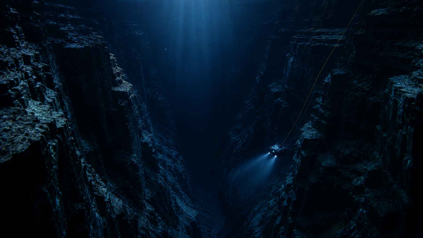
Direct exploration is not easy here. A University of Alaska Geophysical Institute report described marine ecologist Michelle Ridgway piloting an 8-foot submersible into Zhemchug Canyon during a Greenpeace-sponsored expedition and reaching a bench at 1,757 feet.
That is already deeper than most people can comfortably imagine. Still, it was only a fraction of the canyon’s full drop, a bit like stepping onto the first landing of a staircase that continues far beyond the light.
Read More: {{post_title link:post}}
Because human visits are so limited, maps and camera surveys matter. Bathymetry, acoustic tools, models, and remote vehicles are the real windows into this hidden valley, helping scientists understand where vulnerable habitats are and where management choices may need a sharper focus.
Why protection is complicated
The question of protection is not simple. NOAA has noted that coral and sponge habitats can be vulnerable to fishing gear, but it also warned that broad closures can carry unintended consequences if fishing effort simply shifts elsewhere.
That is why scientists and fishery managers need better maps, better habitat data, and a careful look at what is actually living on the bottom. Zhemchug Canyon is spectacular, yes, but it is also part of a working sea where wildlife, fisheries, and fragile habitats meet.
At the end of the day, the canyon’s biggest lesson may be humility. One of Earth’s great landscapes is not under our feet, but under miles of cold water, quietly shaping life in a place most of us will never see.
The official survey summary was published on NOAA Fisheries’ website.