If you have ever slammed the brakes because a deer, boar, or stray dog suddenly appeared in your headlights, you already understand the problem. Roads slice through habitat, and animals do not read warning signs.
India is now testing a different kind of fix on National Highway 45 in Madhya Pradesh. It is a short stretch, but it is packed with design choices that try to protect both drivers and wildlife, using bright red road surfacing, fencing, and 25 dedicated animal underpasses.
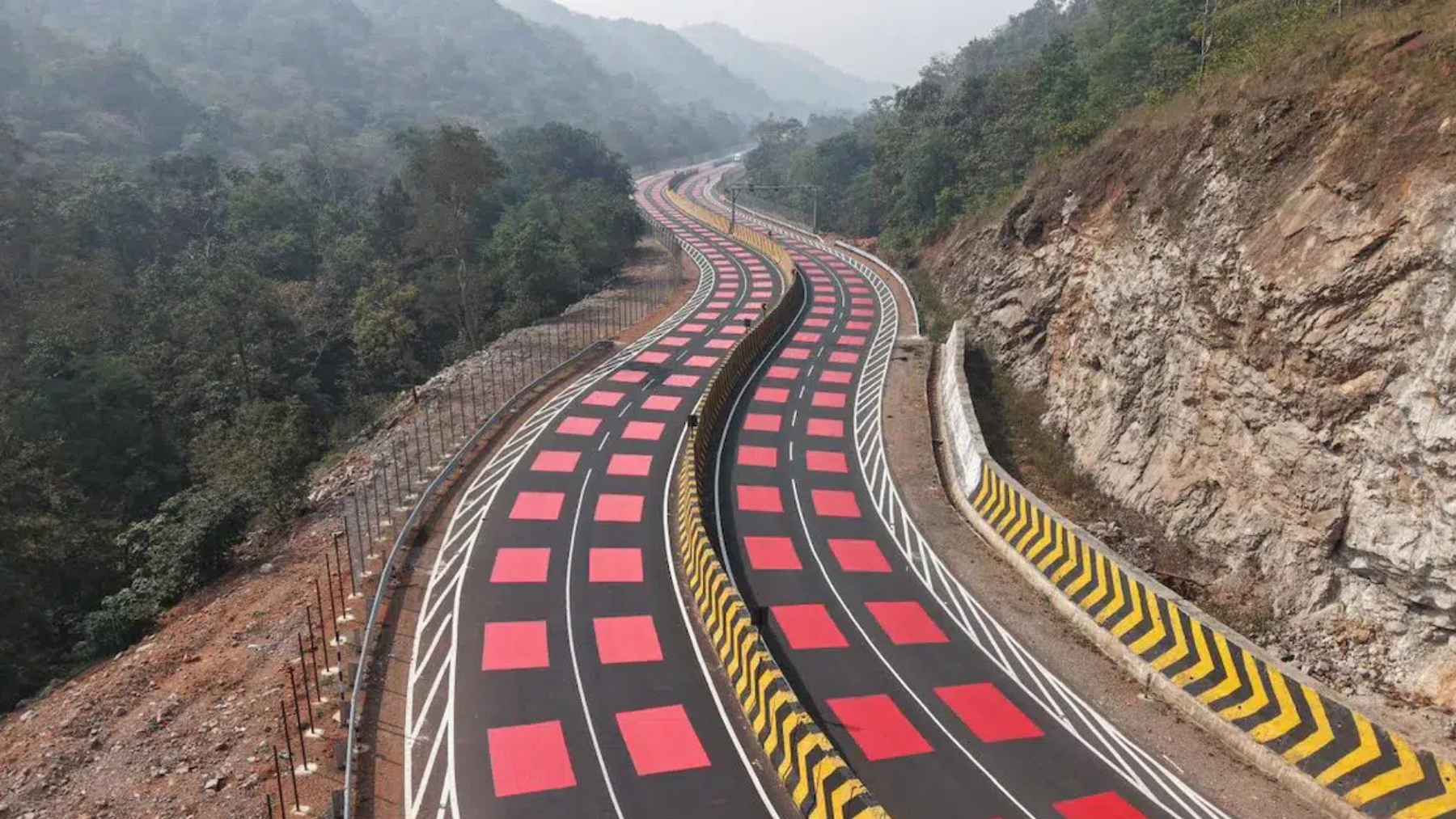
A “red road” built for a wildlife corridor
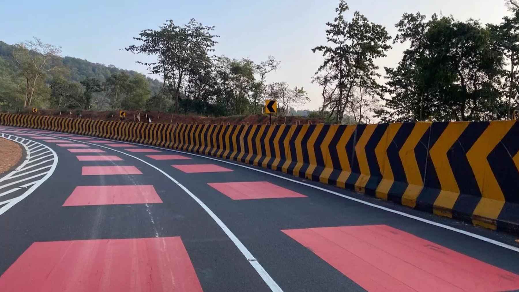
The National Highways Authority of India (NHAI), under the Ministry of Road Transport and Highways, has rolled out what it calls India’s first “table top red marking” on a highway. The work sits on an 11.96-kilometer (about 7.4-mile) project section on NH 45 that passes through the Veerangana Durgavati Tiger Reserve in Madhya Pradesh.
Read More: {{post_title link:post}}
At the heart of the idea is a 5-millimeter (about 0.2 -inch) hot-applied thermoplastic red surface layer placed across a 2.0-kilometer (about 1.2-mile) danger zone. Officials say the bright red color and the slightly raised feel are meant to alert drivers and “naturally” bring speeds down without harsh braking.
The unglamorous part that matters most
Red paint alone does not stop a collision if an animal can still step onto the road. That is why NHAI paired the markings with 25 dedicated animal underpasses placed along the 7.4-mile corridor at identified movement locations.
The press release also describes continuous chain-link fencing along both sides of the highway, designed to prevent animals from entering the roadway and to guide them toward the underpasses.
Cameras on minor bridges that can double as crossing points, plus solar lighting at bridges and junctions, are meant to improve monitoring and visibility without adding a heavy environmental burden.
Why science keeps pointing to crossings plus fencing
Wildlife vehicle collisions are not just an “out there” problem in remote forests. In the United States, federal research has estimated one to two million collisions each year between cars and large animals, which is a big safety issue for people and a major source of wildlife mortality.
What works best, for the most part, is not mysterious. A large meta-analysis found that fencing combined with crossing structures cut large mammal roadkill by about 83%, while fences on their own reduced roadkill by about 54%.
Read More: {{post_title link:post}}
It also found no detectable roadkill benefit from crossing structures without fencing, which is a reminder that animals need guidance, not just a tunnel somewhere nearby.
There is nuance, though. Research in Conservation Biology suggests fencing tends to deliver at least about an 80% collision reduction when it is installed along stretches of 5 kilometers (about 3.1 miles) or more, while shorter fenced segments can be far less predictable. In other words, length and continuity are not details – they are the whole game.
Slowing drivers without turning the road into a police zone
In everyday driving, people respond to cues. A school zone sign, a tight curve, even a change in pavement texture can make you lift your foot off the gas before you consciously decide to.
NHAI is leaning into that psychology. It says the raised red surfacing provides mild tactile and audible feedback, with lower noise than conventional rumble strips, and it is intended to be easy to maintain and even reversible if upgrades are needed later.
That “design instead of enforcement” approach will sound familiar to anyone tired of speed traps, sudden braking, and near misses. But it only earns its keep if the safety outcomes show up in the numbers, not just in how striking the road looks from above.
Chile is betting on the same idea, at a much bigger scale
This is not only an India story. In February 2026, Chile’s Ministry of Public Works announced the award of a major Route 5 concession from Chacao to Chonchi in Chiloé, with an investment of $594 million and upgrades across 126 kilometers (about 78.3 miles).
The plan is broad, with a new Pudeto River bridge of roughly 750 meters (about 2,461 feet), added bridges, pedestrian walkways, lighting, drainage, and service roads. Buried in that long list is the ecological headline: the project includes seven wildlife crossings (also described as ecological corridors) specifically intended to protect the island’s natural environment.
Read More: {{post_title link:post}}
There is still a long runway before anyone can call it a success. Construction is projected to start in 2028 after detailed engineering and an environmental impact assessment, with full operation expected around 2033.
What readers should watch for next
So what will actually tell us whether these “wildlife friendly” roads are working? Three things matter most: speed data through the marked zones, real before-and-after wildlife collision counts, and monitoring evidence that animals are using the crossings instead of searching for gaps in the fence.
Maintenance is the quiet risk. A single broken fence line, a clogged underpass, or poorly managed vegetation can turn a carefully designed corridor back into a trap, and that is true whether the project is 7.4 miles long or 78.3 miles long.
At the end of the day, this is what the “red road” concept is trying to do. Make the human transportation network a little less lethal for the wildlife that was there first, without pretending highways can be “green” just because they run through trees.
The press release was published on the Press Information Bureau.