If you have ever watched a thunderstorm roll in, you know the basics. Dark clouds, a sudden downpour, and lightning that seems to stitch the sky together for a split second. What most of us never see is the storm’s second act, flashes of light that erupt above the cloud tops and can reach far into the upper atmosphere.
NASA and its partners say these upper-atmosphere bursts can disrupt communications and even pose risks for aircraft and spacecraft. That is why researchers are using instruments on the International Space Station, about 249 miles (400 kilometers) above Earth, to capture the action and feed better weather and climate models.
The lightning you cannot see from the ground
Scientists group many of these brief flashes under the term “transient luminous events,” or TLEs. They happen above thunderstorms, often lasting only milliseconds, so clouds and distance make them hard to spot from Earth. You might be standing under a storm and still miss the real show.
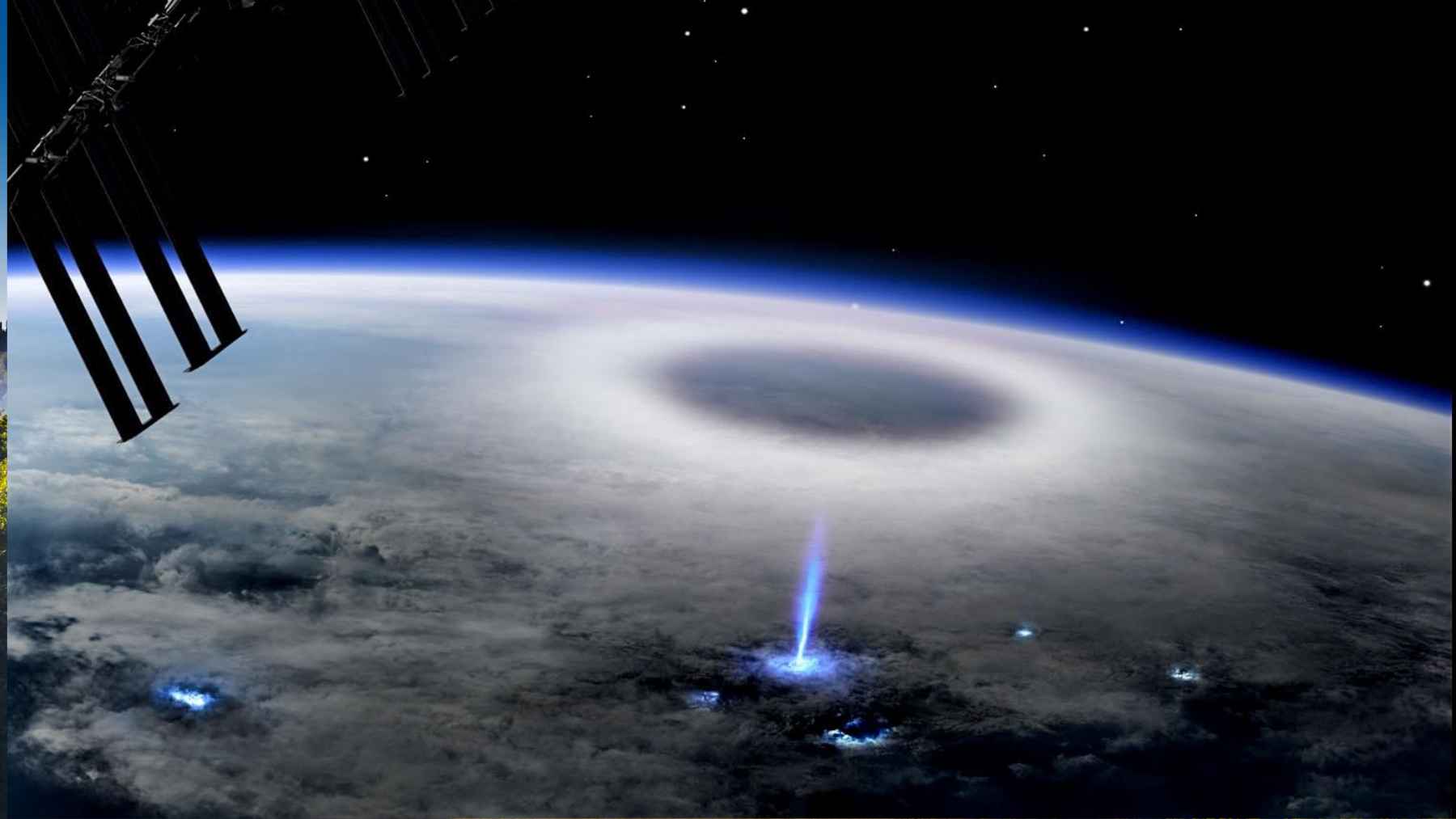
Sprites are the poster child, faint reddish flashes that can appear around 50 miles (80 kilometers) above thunderstorms. NASA notes that reports of strange lights above storms go back a long way, but the first credible sprite footage was captured by chance in 1989. Even now, researchers say there are big gaps in how often sprites form and why they take such varied shapes.
Read More: {{post_title link:post}}
Other TLEs lean into the fairy-tale names. ESA describes “blue jets” as electrical discharges that shoot upward from cloud tops into the stratosphere, while “ELVES” can appear as dim, expanding rings that may span about 249 miles (400 kilometers) across. For events this fast and this high, orbit is a front-row seat.
ASIM is the space station’s storm hunter
One of the main watchers is ASIM, the Atmosphere Space Interactions Monitor, mounted outside the European Columbus laboratory on the ISS. ESA says it was installed in April 2018 using the station’s roughly 52-foot (16-meter) robotic arm to position a facility weighing about 690 pounds (314 kilograms). From that perch, it looks down for lightning and powerful electrical bursts above thunderstorms.
Read More: {{post_title link:post}}
ASIM does not rely on a single sensor. ESA explains it carries optical instruments that work in infrared and ultraviolet, plus X-ray and gamma-ray detectors, with onboard sensors deciding when to capture and send data to Earth.
NASA adds that space-based observations like these can improve atmospheric models used for weather and climate prediction, because the events sit far above normal lightning where ground cameras struggle.
ELVES, coronas, and why the ionosphere pays attention
ASIM’s data is already shaping new findings. NASA reports that research based on ASIM observations confirmed that lightning-like discharges near storm tops can trigger ELVES, those giant rings of light in the upper atmosphere. The same work showed these discharges can influence the ionosphere, a region that affects radio signals and many “space weather” effects.
ASIM has also helped researchers dig into corona discharges, brief but powerful electrical bursts near the tops of thunderclouds. NASA says ASIM-based studies described the physical properties of different corona discharge types and provided reference data for a long-standing problem in lightning physics, how lightning gets started. It is the difference between watching a flash and understanding the wiring behind it.
Thor-Davis brings an ultrafast camera to the Cupola
Not all storm science happens outside the station. NASA says the ESA investigation Thor-Davis tested a special camera used through the Cupola windows that can record thunderstorm electrical activity at up to 100,000 frames per second. That speed matters because some TLEs are over in a blink, literally as little as a millisecond.
ESA and DTU Space describe the Davis device as an “event-based” camera that records changes in light rather than full traditional frames, a bit like how our eyes focus on motion. In practical terms, it can reach microsecond-scale timing while using fewer resources, which is exactly what you want when you are chasing tiny flickers from orbit. It is also aimed at a bigger question, how storms interact with the upper atmosphere and affect greenhouse gases such as ozone.
Light-1 tracks gamma-ray flashes that can reach aircraft
Visible light is only part of the storm story. NASA says JAXA’s Light-1 CubeSat used detectors integrated into a compact satellite to observe terrestrial gamma-ray flashes, or TGFs, in the upper atmosphere. NASA warns these high-intensity events can expose aircraft, aircraft electronics, and passengers to excessive radiation, which turns a niche physics question into an aviation one.
Read More: {{post_title link:post}}
Light-1 also shows how smaller missions can widen the net. NASA describes the satellite as a compact 3U CubeSat using two integrated detectors, designed to be efficient in cost and manufacturing time.
Researchers plan to compare Light-1 data with ground observations to build more complete lightning and thunderstorm maps, and NASA notes small satellite detectors could be cheaper and faster to build than some traditional approaches.
What this means for everyday forecasts and long-term climate
At the end of the day, this is not just about pretty videos from space. NASA says understanding TLEs can improve atmospheric models and weather predictions, the same systems that shape storm warnings, airline routing decisions, and even how utilities plan for heat waves and that electric bill we all dread in midsummer. Better observations also mean fewer unknowns when storms interfere with communication links.
There is also a climate payoff, with appropriate caution. ESA notes that lightning affects concentrations of climate-relevant atmospheric gases, and it emphasizes that chemical changes in the atmosphere still carry large uncertainties, which makes direct measurements valuable.
The official statement was published on NASA’s website.