Imagine sailing for days and never seeing land, then suddenly entering water that feels oddly calm. Out in the North Atlantic, the Sargasso Sea is a “sea” with no coastline at all, outlined by looping currents rather than beaches or cliffs.
That quirk is not just a geography fact you share at dinner. Scientists and conservation groups say the Sargasso’s seaweed rafts function as a nursery for young ocean life, but the same circulation also funnels plastic and other stressors into the region.
A sea drawn by currents
The Sargasso Sea sits about 590 miles east of Florida, and its border is made of moving water. It is held in place by the North Atlantic subtropical gyre, a clockwise loop of major currents that naturally concentrates floating material.
Read More: {{post_title link:post}}
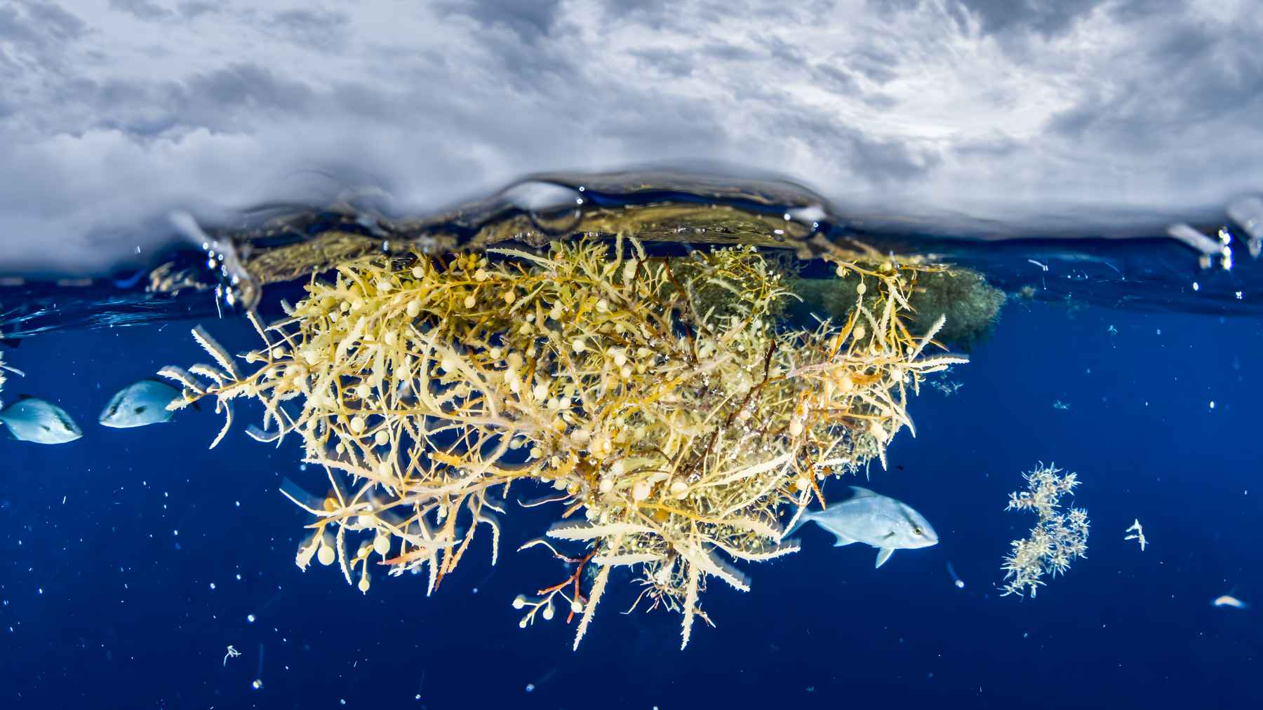
Inside that ring, the surface can look almost glassy compared with surrounding waters. One reason is Sargassum, a golden-brown seaweed that floats thanks to tiny gas-filled bladders and gathers into drifting mats.
It is named for the floating Sargassum that carpets its surface. And once you spot those loose “floating forests,” it becomes clear this is not an empty blue patch on the map.
Floating forests that raise young
From above, Earth.com describes the Sargasso as an 800-mile-wide nursery, and researchers call the mats “habitat islands” for good reason. In open ocean, shade and structure can mean the difference between a young animal surviving and disappearing.
NOAA notes that Sargassum provides a nursery for juvenile fish, including species like tuna and billfish, and it also supports endangered sea turtles during early life stages. NOAA also points to the Sargasso as spawning habitat for endangered anguillid eels and a pupping location for the endangered porbeagle shark.
Read More: {{post_title link:post}}
So why should anyone on land care? Because food webs and migrations do not respect borders, and many Atlantic species pass through this zone at some point in their lives. What happens in the nursery rarely stays in the nursery.
A quiet climate engine
The Sargasso does climate work that is easy to miss if you only look at the surface. In summer it warms to about 82 to 86°F, and in winter it cools to roughly 64 to 68°F, influencing how heat and moisture move through the Atlantic system.
Long-term measurements near Bermuda show a clear direction of travel. An open-access analysis linked to the Bermuda Atlantic Time-series Study reports surface warming of about 1.5°F since the 1980s, with recent warming closer to about 2.2°F, alongside declines in dissolved oxygen and a drop in pH of about 0.07.
This connects to the bigger carbon story. The IPCC reports that the surface ocean has absorbed about a quarter of human-caused carbon dioxide emissions, and that chemical uptake is what drives ocean acidification. Tracking that shift increasingly relies on long-time-series sites plus tools like Argo floats that can help monitor acidity and carbon remotely.
When the gyre becomes a trash net
The same currents that corral Sargassum also corral our trash. The Sargasso Sea Commission reports that, in the Sargasso study area cited by Law and colleagues, sampling at times reached the equivalent of more than about 520,000 plastic pieces per square mile.
This problem has been building for decades. Woods Hole Oceanographic Institution notes that scientists reported floating plastic in the Sargasso as far back as 1972, and later long-term sampling found buoyant plastic in more than 60% of surface tows in the western North Atlantic.
Read More: {{post_title link:post}}
Zoom out, and the scale is sobering. UNEP says humanity was expected to use more than about 550 million U.S. tons of plastic in 2024, with roughly 440 million tons quickly becoming waste, a pipeline that feeds ocean accumulation even when most items start life on land.
Who protects a sea that belongs to everyone
Here is the uncomfortable catch. Much of the Sargasso lies beyond any one country’s jurisdiction, and its protection depends on cooperation across shipping, fisheries, and pollution rules. The Sargasso Sea Commission is designed as a stewardship body, but it has “no management authority.”
Near coasts, the picture is clearer. NOAA’s maritime boundary guidance describes the territorial sea as extending up to about 14 miles from a coastal baseline, but the Sargasso mostly sits far beyond that, in a legal space where enforcement can be expensive and slow.
That is where the new global tools come in. Germany’s environment ministry says the UN BBNJ Agreement entered into force in January 2026 and can support protected areas on the high seas, while UNEP notes that plastics treaty negotiations continued with a resumed session in February 2026 that handled administrative issues without substantive talks.
This coastless sea is a perfect test case for whether those processes can deliver real protection, before the ocean’s “trap” fills up even more. At the end of the day, the Sargasso Sea is a reminder that the ocean connects everything, from seafood counters to the storm forecasts on your phone.
The official update was published on UNEP.