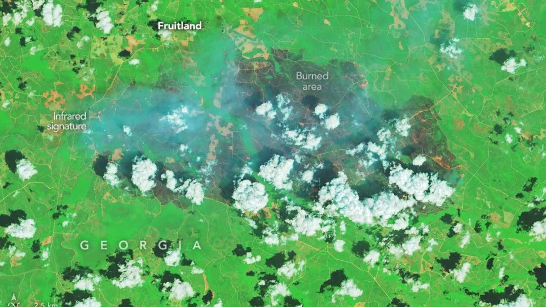
What does a wildfire look like from space? In southern Georgia, NASA’s Landsat 8 saw it as a wide gray mark across green forest, the signature left by two destructive fires that grew under extreme drought, gusty winds, and dry debris left behind by Hurricane Helene.
The Pineland Road and Highway 82 fires have burned 54,450 acres combined, an area of about 85 square miles, according to the latest Georgia Forestry Commission update on May 19. Both were 90% contained, but crews were still in patrol, suppression, and mop-up mode, which is a reminder that containment is progress, not the same as a fire being gone.
A scar seen from orbit
NASA’s Earth Observatory published false-color Landsat 8 images acquired on April 23 by the Operational Land Imager. In those images, burned areas appear gray, living vegetation appears green, and active fire fronts show up in orange because of their infrared heat signatures.
From the ground, the same disaster was felt in a much messier way. Think closed roads, smoky air, property damage, and emergency vehicles moving through communities such as Atkinson and Fruitland.
Read More: {{post_title link:post}}
The view from orbit matters because it shows the scale all at once. A fire line that feels scattered on the ground becomes one continuous wound on the landscape.
Drought turned fuel into tinder
The Southeast was already in trouble before the sparks came. A Drought.gov update on April 16 found that 96.83% of the region was in moderate to exceptional drought, while 81.75% was in severe to exceptional drought, the broadest such footprint since the U.S. Drought Monitor began in 2000.
The same update said rainfall deficits dated back to July 2025, with many places running 8 to 16 inches below normal over nine months. That is not just a number on a weather chart. It is the dry grass beside a road, the brittle branch in a ditch, and the forest floor ready to burn.
Hurricane Helene added another layer of risk after it crossed the region in September 2024. NASA noted that fallen trees and limbs left by the storm helped fuel the fires, which is how an earlier disaster can quietly set the table for the next one.
Two small sparks, one huge fire zone
Investigators traced the Pineland Road Fire to a stray spark from welding that fell onto the forest floor and ignited nearby vegetation, according to the Georgia Forestry Commission. The agency said that fire started in Clinch County on April 18 and had burned 32,031 acres by May 19.
The Highway 82 Fire began two days later in Brantley County. Officials said its cause was a Mylar balloon that touched a power line, creating an electrical arc that ignited vegetation, and the fire had burned 22,419 acres by the latest update.
That detail is hard to ignore. A welding spark and a shiny balloon sound ordinary, but in a parched landscape they became ignition sources for one of Georgia’s most damaging wildfire episodes in years.
Containment is not the finish line
By May 19, both large fires were listed at 90% containment, a major improvement from late April. Still, the Forestry Commission warned that fuel conditions remained extremely dry and crews were actively working on patrol, suppression, and mop-up operations.
In practical terms, containment means firefighters have strengthened control lines around much of the perimeter. It does not mean every hot spot is out, and it does not mean wind, low humidity, or hidden embers can be ignored.
That is why residents were still being urged to stay out of active fire areas, keep drones away from wildfire airspace, and use caution when smoke reduces visibility. The agency’s blunt warning sums it up well. “One spark can still quickly become a wildfire.”
Homes and roads paid the price
The satellite image may show gray acreage, but the human toll is harder to capture from orbit. By April 25, NASA said reports indicated the fires had destroyed more than 120 homes, described as the most homes lost to wildfire in Georgia’s history.
For families, that is not an abstract record. It is a kitchen table, a porch, a family photo album, and the everyday comfort of knowing where you will sleep tonight.
Read More: {{post_title link:post}}
The Pineland Road update listed 140 civilians affected, with no civilian deaths, injuries, or missing people reported for that fire, as well as one responder injury or illness. It also noted threats to residences, hunting camps, commercial timber, bee operations, transportation corridors, utilities, transmission lines, and railroad lines.
Emergency response grew quickly
Governor Brian Kemp declared a state of emergency for 91 Georgia counties on April 22. His office said the order allowed the Georgia Department of Defense to mobilize National Guard troops and resources, including air assets, while state agencies helped with helicopters, engines, dozers, evacuations, and livestock relocation.
Kemp warned that “wildfires have already surpassed the state’s five-year average and continue to spread.” The state also issued a burn ban for the same 91 counties, covering activities such as prescribed burns, yard debris burning, and agricultural burning.
That kind of response shows how quickly a local fire can become a regional emergency. Fire does not care where a county line sits on a map.
Satellites are becoming firefighting tools
NASA’s image is dramatic, but it is not just for public attention. The agency says satellite and aircraft data are part of a global observation system used to track fire behavior, analyze trends, and help operational agencies manage wildfires.
NASA also points to tools such as FIRMS, Worldview, and Fire Event Explorer, which help turn heat signatures, smoke plumes, and burn scars into information that crews and planners can use. That matters when smoke blocks the ground view or roads become unsafe.
Read More: {{post_title link:post}}
After the flames fade, the same view from above can guide recovery. Burned land may face erosion, damaged habitat, weakened tree cover, and the risk that another dry spell will make the landscape dangerous again.
The warning from Georgia
The Georgia fires show how modern wildfire risk often builds quietly. Drought dries the landscape, storm debris piles up, wind pushes flames, and then one small ignition point unlocks the whole chain.
Seen from space, the gray scar is a warning. On the ground, it is a reminder that prevention can be as important as the firefight itself, from avoiding sparks in dry grass to respecting burn bans and leaving fire aircraft room to work.
The satellite image report was published on NASA Earth Observatory.