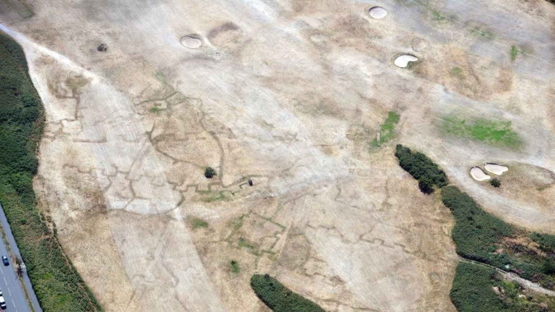
On the ground, many fields across Wales looked like little more than sun-dried grass. From the air, they became a layered map of human history, revealing a roughly 5,000-year-old Neolithic long barrow near Welshpool, buried Roman buildings at Caerhun, First World War practice trenches at Deganwy, and an unrecorded Iron Age or Romano-British farmstead near Llandysul.
The findings give archaeologists a rare window into sites that can stay hidden for decades or centuries, but the reason they appeared is a far less welcome phenomenon. Wales had received only 5% of its expected July rainfall by July 16, and Natural Resources Wales later extended drought status across the entire country as rivers, habitats, and farmland fell under growing pressure.
The fields are acting like an X-ray
How can an hidden ditch turn green? When old ditches, pits, or postholes are filled with deeper, looser soil, they often retain more water and nutrients than the ground around them, allowing plants on the surface to grow taller or stay greener during dry spells.
Buried walls, roads, and compacted floors, however, can create the opposite effect because roots have less soil and moisture. Looking down from a plane, these contrasts form cropmarks or parchmarks that trace shapes no one surveying the field on foot may notice.
Four eras surface at once
Near Welshpool in Powys, aerial photographs showed the rectangular outline of a Neolithic long barrow dating to about 5,000 years ago. At Caerhun Roman fort in Conwy, the drought uncovered new detail in the foundations of buildings inside a site also known as Canovium.
The same flights recorded a much different chapter of the past beneath a golf course at Deganwy, where First World War practice trenches appeared in the parched grass fairways. Near Llandysul in south Ceredigion, ripening crops also exposed a previously unknown double-ditched farmstead that experts provisionally place in the Iron Age or Romano-British period.
The race to record them
These marks can fade almost as quickly as rain returns, crops are harvested, or vegetation comes back. That is why Dr. Toby Driver, an archaeologist with the Royal Commission on the Ancient and Historical Monuments of Wales, has been making several flights from Haverfordwest and Caernarfon while working around difficult winds.
“Sometimes the cropmarks are so clear they jump out,” Driver said, but others are so faint that the Royal Commission digitally rebalances the color bands in the photos to increase contrast. The process does not create archaeology but makes patterns already captured by the camera stand out more clearly for mapping and studying.
What the images can show
A striking aerial outline is evidence of a buried feature, not confirmation of exactly what it was or when it was built. Archaeologists compare the shape with known monument types and earlier photographs, then may use some combination of mapping, geophysical survey, field inspection, or even targeted excavation to test the interpretation.
That explanation matters for the newly recorded Llandysul farmstead, which is described as Iron Age or Romano-British, but not assigned a single confirmed era. The images are the intriguing opening clue, not the closed case.
A discovery with an environmental cost
The dry spell has created extraordinary visibility, but it is also taxing the living landscape. Natural Resources Wales reported exceptionally low river flows, drying riverbeds, fish in distress, and concerns over crops, grazing conditions, water supplies for livestock, and wildfire risk as drought spread nationwide.
Provisional Met Office figures show Wales received less than a half-inch of rain in July, only 9% of its 1991 to 2020 average, reaching the country’s driest July on record. Natural Resources Wales estimates that prolonged dry weather has become more likely as climate change accelerates, increasing the possibility that these archaeological windows may open more frequently even as the environmental consequences become more than just inconvenient.
Why this summer’s record matters
This is not the first time that Wales has seen how much evidence one dry summer can produce. During the 2018 drought, the Royal Commission took about 5,700 aerial photographs on 17 flights and eventually identified around 200 new archaeological sites, showing that the real work continues long after the grass flourishes again.
For a few weeks, the 2026 heat made thousands of years of history newly visible, and the photographs will preserve details that the next rain may erase from view.