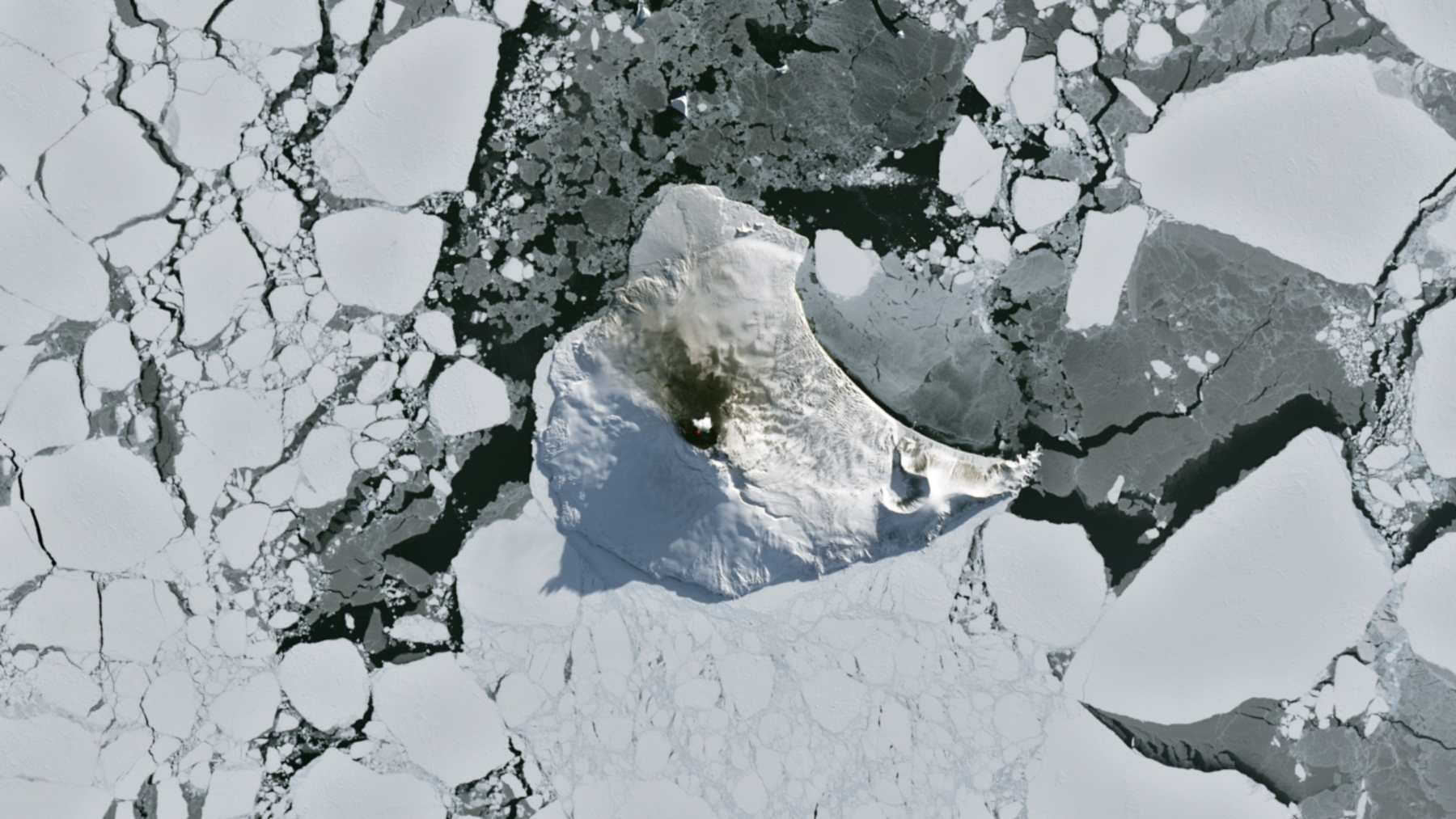
A lava lake inside Mount Michael showed up as a red speck of heat in a satellite image taken on August 24, 2026. Mount Michael is the stratovolcano in the middle of Saunders Island, out in the South Atlantic. When NASA’s Earth Observatory ran the picture on September 7, it said this corner of the map was “still very much awake, at least volcanically speaking.”
Clouds hide the summit on most days, so a clean view like this one does not come often. According to the NASA Earth Observatory report, the image also caught a small plume over the summit. Darkened snow on the northern slopes pointed to ongoing activity as well.
Heat in bands 7-6-5
The picture came from the Operational Land Imager on Landsat 8, which NASA runs with the U.S. Geological Survey. For this view, NASA laid an infrared signal from OLI bands 7, 6 and 5 over a natural-color scene, so the crater’s heat appears in red.
The red is a display color added to the image. In a 2019 feature on the same crater, NASA showed that in a natural-color view you can no longer discern the lava lake.
Around the island, the ocean is packed with broken sea ice. NASA says winter near the Antarctic Circle brings months of frozen darkness to these cold southern waters.
Thirty years of hot pixels
A lava lake is a pool of molten rock that stays in a crater between eruptions. Scientists first picked up unusual heat at Mount Michael in the 1990s. Back then, nobody could say from those blurry images whether it was a stable lake or a temporary pool.
Danielle Gray, then a graduate student at University College London, led a team that went back through three decades of Landsat, Sentinel and ASTER images. Their 2019 study in the Journal of Volcanology and Geothermal Research confirmed a persistent lake.
“The persistence of the anomaly and high temperatures was the key to identifying the lava lake,” Gray said in NASA’s 2019 account. The hottest pixels read 543 to 786 degrees Fahrenheit (284 to 419 degrees Celsius), while cracks of molten lava can reach about 2,334 degrees Fahrenheit (1,279 degrees Celsius).
The team put the lake at about 360 feet (110 meters) wide. Its area came to roughly 108,000 square feet (10,000 square meters), or about eight Olympic swimming pools, by NASA’s comparison.
Almost nonstop since 2014
Saunders belongs to the South Sandwich Islands, a chain of volcanic peaks about 220 miles (350 kilometers) long. The chain formed where the South American plate slides beneath the tiny South Sandwich plate. Geologists call this process subduction.
Mount Michael rises 2,766 feet (843 meters), according to the Smithsonian’s Global Volcanism Program. Its reports say the volcano has been in almost continuous eruption since November 2014. A National Geographic Society team that reached the summit in November 2022 confirmed the lava lake.
Because visits are so rare, most of the record comes from orbit, as with the satellite watch on an underwater eruption off Papua New Guinea. Data from the MODIS and VIIRS instruments point to years of low-intensity activity. NASA’s Aura satellite shows that sulfur dioxide emissions are common.
Only a handful of other volcanoes, including Kilauea, Nyamulagira and Erta Ale, host similar lakes that stay active this often, NASA notes.
Wake-shaped clouds on September 1
The clear spell did not last. When Landsat 9 passed over on September 1, the clouds were back. The peak was bending the winds into wave clouds that trailed downwind like the wake of a ship.
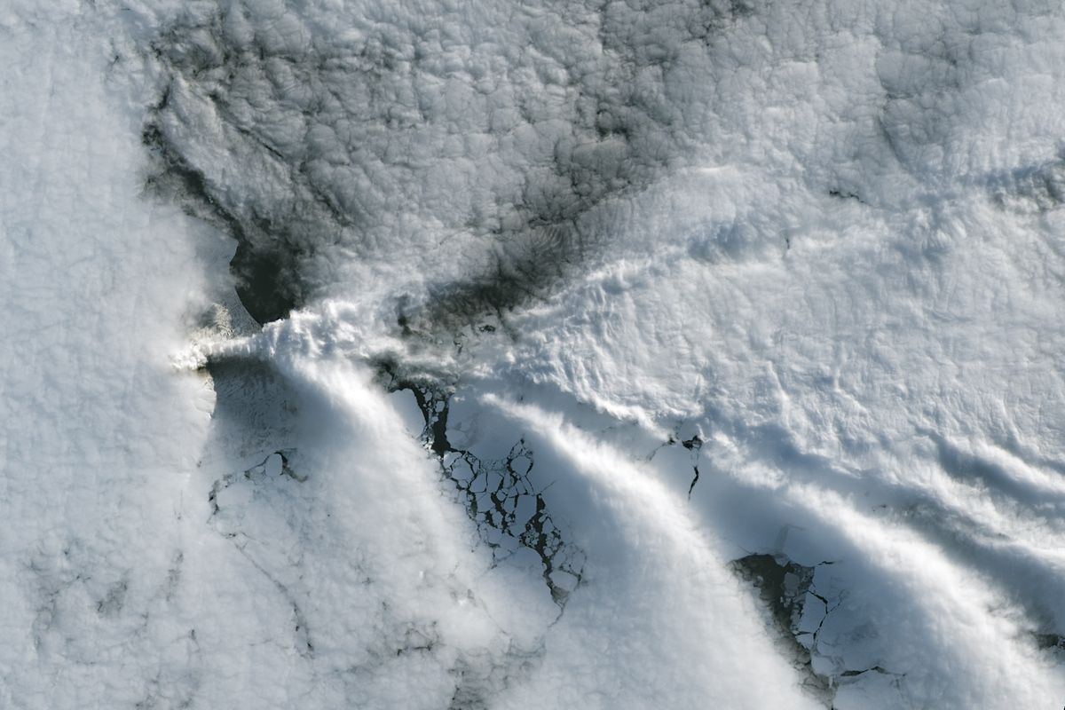
NASA research meteorologist Galina Wind described this effect over the islands in 2020. “The moving air hits the still mountain in the same way the prow of a moving boat hits still water,” she said. Clouds form at each wave crest and vanish in the dip.
Something else was likely in the air that day. False-color images from NASA’s Aqua satellite suggest a volcanic track from degassing sulfur dioxide.
Volcano tracks and ship tracks
Clouds that pick up extra particles from volcanoes hold more droplets, each one smaller. That gives them more surfaces to reflect light, so they look brighter than the clouds around them. NASA’s 2020 feature on volcanic emissions and clouds calls this the Twomey effect.
Ship exhaust does the same thing over busy ocean lanes, leaving bright tracks in marine clouds. It is also central to research on how cleaner air is changing marine clouds. In mid-May 2020, NASA satellites saw volcano tracks off Mount Michael nearly every day for two weeks.
Santiago Gassó, a NASA and University of Maryland atmospheric scientist, has followed these tracks since 2008. “With the volcano tracks from the South Sandwich Islands, there is no question at all,” he said in 2020. Elsewhere, he explained, weather shifts can mimic the brightening.
The 360-foot figure dates from 2018
NASA’s 2026 report gives no new size or temperature for the lake. The width and area above come from the 2019 study, which used images such as one from January 31, 2018.
Clouds cover the crater on most days and leave long gaps in the record. For September 1, NASA calls the volcanic track likely, not measured.
The official report was published on September 7, 2026, by NASA Earth Observatory as its Image of the Day.
Image: NASA Earth Observatory/Michala Garrison