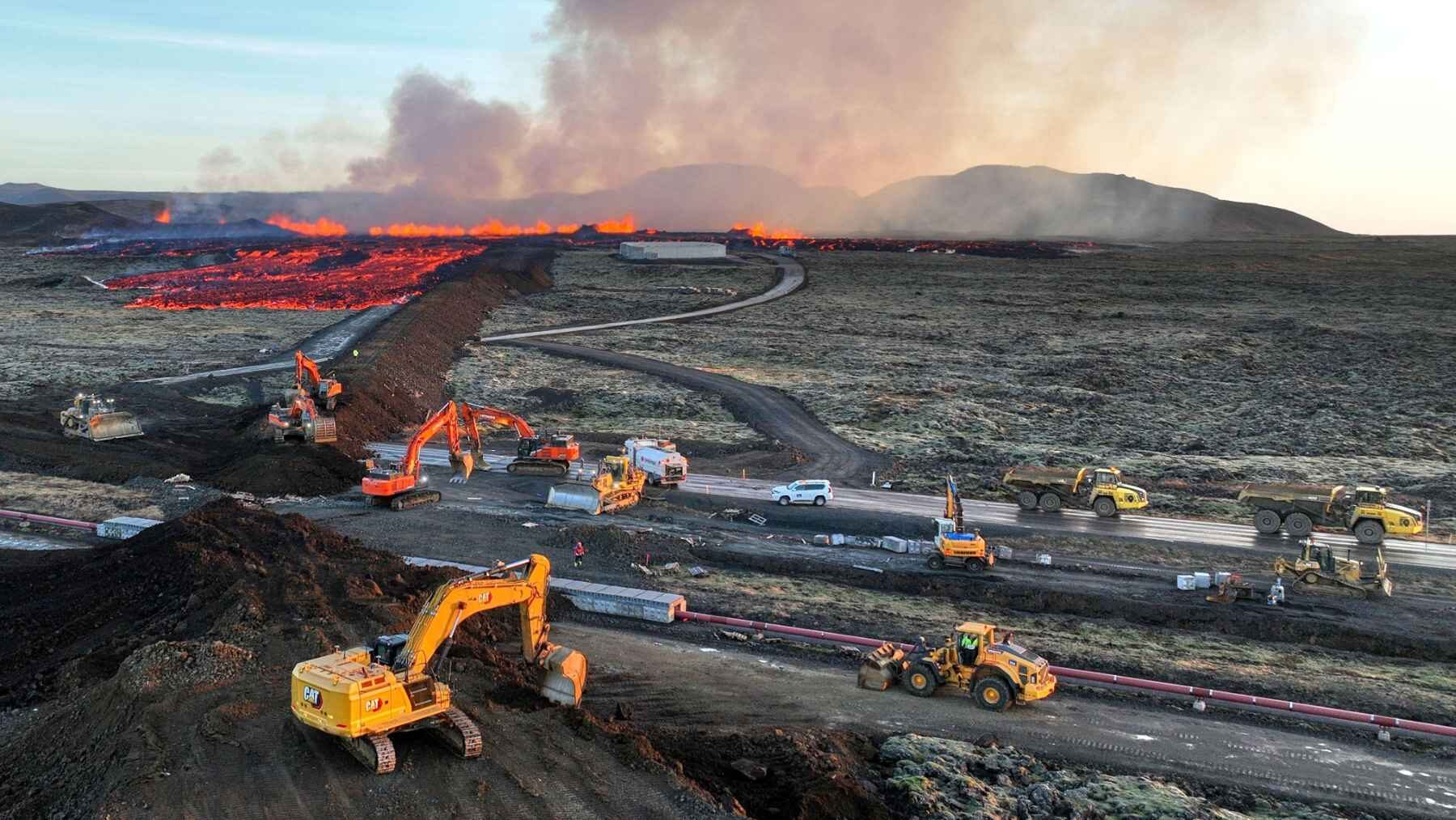
The machinery around Grindavík sits idle, but the danger lurking below Iceland’s Reykjanes Peninsula does not. As of January 15, 2026, protective barrier work was halted and machinery was being held on standby, while the most recent official report indicates earlier magma intrusions provided between 20 minutes and just over 4 hours of warning.
The ninth eruption in the Sundhnúkur sequence ended on August 5, 2025, and no eruption has reached the surface since. Yet on July 21, 2026, the Icelandic Meteorological Office estimated that 28.3 million m³ of magma had accumulated beneath Svartsengi, with an uncertainty range of 27.5 million to 29.1 million m³.
These are ramps, not walls
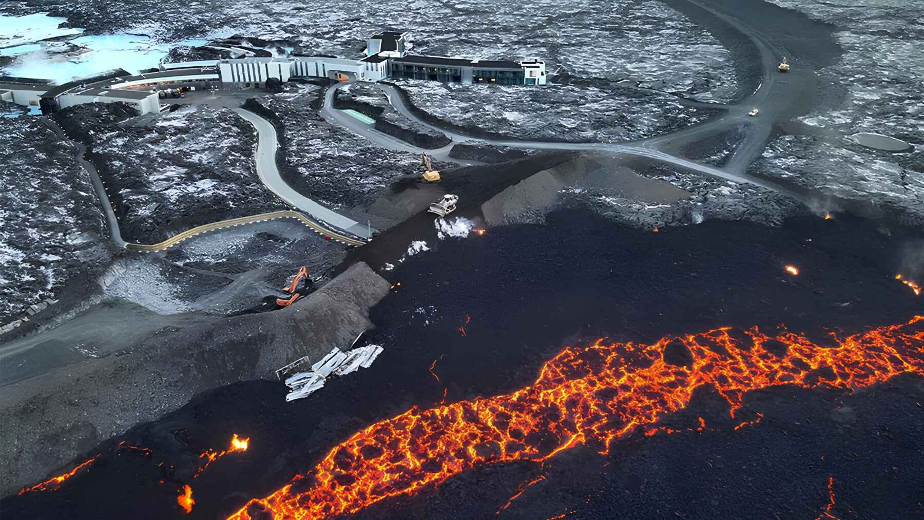
A barrier placed directly in front of lava may slow it, but the flow can pile up and eventually spill over. Iceland’s embankments are angled across likely flow paths instead, guiding molten rock away from Grindavík, the Blue Lagoon, and the Svartsengi geothermal facilities.
Engineers modeled those routes with HEC-RAS, software normally used for river hydraulics, while treating lava as a Bingham fluid and updating the terrain with drone surveys. It sounds like flood engineering applied to an impossible material, but the models could be recalibrated against real flow behavior after each eruption.
Fourteen kilometers of local rock
A 2026 review in the journal Natural Hazards describes about 14 kilometers of barriers, heights reaching 25 meters, and roughly 3 million m³ of construction material used by September 2025. In imperial measures, the defense stretches about 8.7 miles and rises as high as 82 ft. in its tallest sections.
The fill includes basaltic lava, tuff, and tephra excavated from nearby sites. Researchers called it remarkably unconsolidated by conventional levee standards, yet reported that it had remained impermeable to lava through the events studied.
Nearly 100 machines worked around the clock
Work around Svartsengi began in November 2023, soon after Grindavík was evacuated. Ari Guðmundsson of Verkís described the pace to Construction Briefing by saying, “We are working both day shifts and night shifts, 22 hours a day.”
By late January 2024, Reuters reported that nearly 100 bulldozers, excavators, and haul trucks were operating around the power plant. For clarification, the force involved nearly 100 heavy machines, not 100 bulldozers alone.
The defenses worked, with limits
The clearest failure came on January 14, 2024, when an eruptive fissure opened inside the defended area and lava destroyed three houses. Another fissure about 500 meters long opened nearby on April 1, 2025, although that eruption was small and short-lived.
No embankment can redirect lava that emerges behind it. Even so, the Natural Hazards review credits the wider system with preventing far greater damage, while noting that lava still covered much of the Blue Lagoon’s original parking area and destroyed its transit center and restrooms during the November and December 2024 eruption.
The price tag was corrected
The verified cost of the barrier system through the end of 2025 is 11.6 billion Icelandic krónur, or about $95.1 million using the exchange rate applied by the researchers. A July 2026 correction replaced the original published figure of 19 billion krónur, which had overstated the cost by roughly $60 million.
Iceland also spread part of the burden across property owners through a temporary annual prevention levy. Parliament set it at 0.08 per mille of a property’s fire-insurance value, equal to 0.008% (not 0.08%), and projected revenue close to 1 billion krónur in 2024.
The barriers are only part of the bill
The human and financial costs reach well beyond rock and machinery. The review places Iceland’s total investment in the emergency at about $1 billion and says the state-backed company Þórkatla bought more than 950 Grindavík residences, with property purchases totaling 72 billion krónur.
Nearly 4,000 displaced residents represented about 1% of Iceland’s population. A quiet construction site can hide that reality, but the empty homes and disrupted lives remain part of the volcanic landscape.
Water was not the main answer this time
Iceland did use seawater on a huge scale during the 1973 Eldfell eruption on Heimaey. According to the U.S. Geological Survey, crews pumped a total of 6.8 million tons of seawater onto the lava in an effort to cool and slow it.
Water has also been used near Grindavík, but in much smaller quantities and mainly to harden fresh lava so construction vehicles could cross it. This time, the main steering tool has been earth and rock.
Why 20 minutes changes everything
The Icelandic Meteorological Office says uplift remains slow but steady and seismic activity remains low, while a new dike intrusion toward the Sundhnúkur crater row, possibly followed by an eruption, is still the most likely scenario. The office’s hazard assessment remains valid through September 30, 2026.
The volume estimate does not provide a precise eruption date or size, but it helps explain why keeping machinery nearby is a practical precaution and why infrastructure supplying water to communities of about 30,000 people remains central to emergency planning.
The latest official update was published on the Icelandic Meteorological Office website.