El Niño has returned to the tropical Pacific, and this one is already raising concern among climate scientists. NOAA’s Climate Prediction Center says El Niño conditions are now present and are expected to strengthen into the Northern Hemisphere winter of 2026-27, with a 63% chance of reaching the “very strong” category during November through January.
That does not mean every region will see disaster. It does mean the climate system has been given a powerful shove at a time when oceans and the atmosphere are already unusually warm. Storm tracks, rainfall patterns, wildfire risk, agriculture, and even the global temperature record might all suffer disturbances.
What El Niño really is
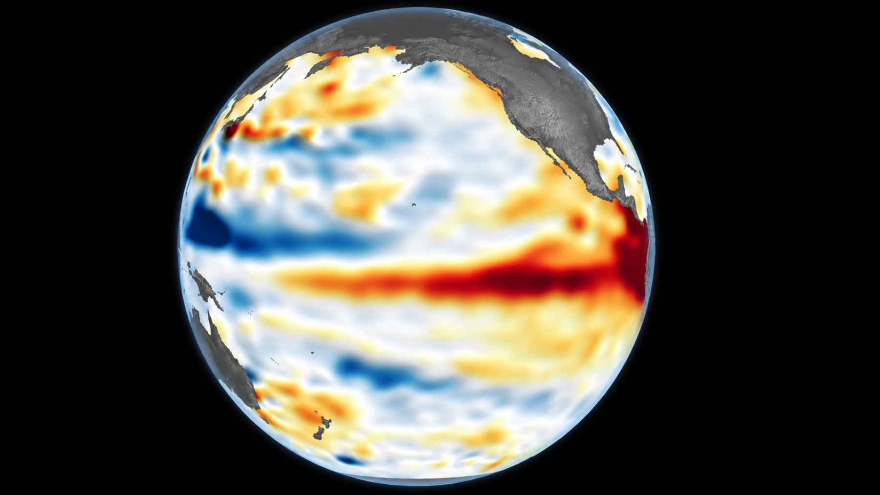
El Niño begins when the central and eastern tropical Pacific Ocean becomes unusually warm at the surface. In NOAA’s latest update, the weekly Niño-3.4 region was 1.3 degrees Fahrenheit above average, while the far eastern Niño-1+2 region was about 3.8 degrees Fahrenheit above average.
Kevin Trenberth, a climate scientist at the University of Auckland and a leading researcher affiliated with the National Center for Atmospheric Research, describes the Pacific as storing heat until the system can no longer hold it in place. In his words, the ocean reaches a point where it seems to say, “I can’t stand it anymore. I’m going to have an El Niño.”
That warm water does not just sit there. It changes the way heat and moisture move between ocean and atmosphere, and those shifts ripple outward through the world’s weather patterns.

Why “super” needs caution
The term “super El Niño” is easy to understand, but it is not an official scientific category. The World Meteorological Organization says it does not use that label in its standardized operational classifications.
NOAA instead uses categories tied to sea-surface temperature departures in the Niño-3.4 region. A “very strong” El Niño means the index reaches at least 3.6 degrees Fahrenheit above average, and NOAA’s June 2026 probabilities show the highest risk of that happening in late 2026 and early 2027.
So, is this a monster event? Maybe, but not every strong El Niño behaves the same way. As NOAA notes, stronger events can tilt the odds toward expected impacts, but they do not guarantee the same result everywhere.
Storms, heat, and fire risk
In the United States, El Niño often raises the chance of wetter conditions across the southern tier, including parts of Southern California. For people used to long dry spells, that can sound like relief, but too much rain too quickly can also mean flooding, mudslides, and damaging storms.
The flip-side of this phenomenon is fire. Trenberth warned that parts of the western United States have already been hot and dry, which leaves some areas vulnerable if rain does not arrive where it is needed most. That is the uncomfortable part of El Niño. It can bring water to one place and leave another exposed.
Think of the electric bill during a sticky summer heat wave, or the smoke that turns the afternoon sky dull gray. These are not abstract climate charts. They are the kinds of everyday disruptions that make early warnings matter.
The Global South may feel it first
El Niño’s impacts often hit hardest in regions where farming, food prices, and water supplies depend heavily on seasonal rainfall. The World Meteorological Organization says El Niño is typically linked with drier conditions in parts of Central America, northern South America, the Caribbean, Australia, Indonesia, and southern Asia.
That matters for monsoons. Trenberth warned that a more active Pacific can weaken rainfall across Southeast Asia, where many communities rely on monsoon rains for crops after months of dry weather. Less rain at the wrong time can quickly become a food security problem.
Africa can also see complicated effects. Warm Pacific water can influence the tropical Indian Ocean, which in turn can shape rainfall in East Africa and affect the risk of drought, flooding, insects, and disease outbreaks. Not neat. Not simple.
A warmer world raises the stakes
El Niño is natural, but it is now unfolding on top of human-driven climate change. WMO says El Niño typically increases global temperatures and can drive more extreme weather and rainfall patterns, while above-average temperatures are forecast across much of the world for June through August 2026.
WMO Secretary-General Celeste Saulo said the world needs to prepare for a potentially strong El Niño, warning that it can worsen drought, heavy rainfall, heat waves on land, and marine heat waves. She also noted that the 2023-24 El Niño was among the five strongest on record and played a role in the record global temperatures seen in 2024.
By the EU’s own kind of climate logic, this is where prevention meets adaptation. Cutting fossil fuel emissions matters for the long game, but farmers, cities, utilities, and emergency planners also need practical forecasts right now in order to respond accordingly.
Monitoring may make the difference
El Niño is not something people can stop once it starts. What they can do is watch it closely and try to mitigate the risks.
That depends on ocean buoys, satellites, forecast models, and national weather services sharing information quickly. Trenberth pointed to anchored tropical Pacific buoys as a key monitoring system, warning that when maintenance falls behind, the flow of information suffers.
At the end of the day, forecasts are not just for scientists. They help farmers decide what to plant, water managers plan for shortages, health officials prepare for heat, and families understand why this winter’s storms may not behave like last year’s.
The official statement was published on NOAA’s Climate Prediction Center website.