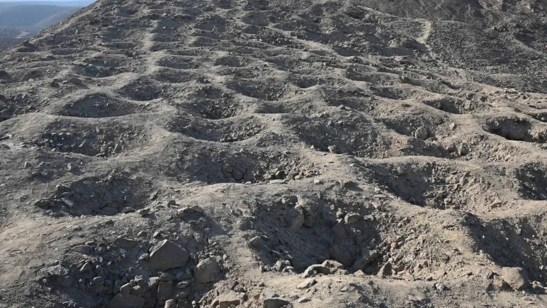
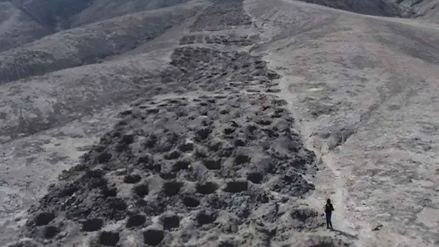
For nearly a century, a strange band of thousands of holes carved into a Peruvian hillside has puzzled archaeologists. Stretching almost a mile along a ridge above the Pisco Valley, Monte Sierpe, or “Serpent Mountain,” looks deliberate, repetitive, almost mathematical. But what was it for?
Now, new research suggests the answer may be surprisingly practical. Instead of a ritual site or a defensive structure, the so-called “Band of Holes” may have functioned as an Indigenous system of trade and accounting, built into the landscape itself during the Late Intermediate Period, around the 1300s.
A mile-long band of carefully arranged holes
Monte Sierpe consists of roughly 5,200 shallow pits carved into the slope of a narrow ridge. Each hole measures about 3 to 6.5 feet wide and roughly 1.5 to 3 feet deep. From a distance, the band appears continuous, but closer inspection shows it is divided into blocks separated by open spaces that allow people to walk across the ridge.
Using high-resolution drone mapping, researchers documented the layout in unprecedented detail. They identified clear numerical patterns in the arrangement of the holes. Some sections contain long runs of identical rows, while others alternate between specific counts in a repeated sequence.
Read More: {{post_title link:post}}
Dr. Jacob Bongers, lead author of the study and a digital archaeologist at the University of Sydney, said the design appears intentional rather than decorative. “Why would ancient peoples dig more than 5,000 holes into the foothills of southern Peru?” he asked.
“We don’t yet have all the answers, but we now have promising new data that support innovative theories about how the site was used.”
Clues in the soil
The team also analyzed sediment from inside the holes. What they found changed the conversation. Ancient pollen and plant remains included maize, a staple crop in the Andes, along with bulrush reeds traditionally used in basketry.
They also identified traces of squash, amaranth, cotton, chili peppers, and other crops that are not grown on the dry hillside where Monte Sierpe sits today.
Many of these plants produce little airborne pollen, which makes it unlikely that the material drifted into the pits naturally. Instead, the researchers argue that people likely transported goods to the site and placed them inside the holes, possibly using woven baskets or bundles made from plant fibers.
In other words, these pits may once have held real products. Food. Fibers. Trade goods. Imagine rows of filled holes visible from a distance, each one representing a quantity of something valuable.
A marketplace without money
Radiocarbon dating places active use of the site in the 14th century, during the Late Intermediate Period. At that time, the Chincha Kingdom dominated the region.
Historical records describe the Chincha as skilled merchants who operated trade networks along the coast and inland long before the rise of the Inca Empire.
Monte Sierpe sits at a strategic crossroads between ecological zones and major pre-Hispanic roads. That location would have made it an ideal meeting point for exchange.
Read More: {{post_title link:post}}
Bongers suggests the site may have functioned like a pre-Inca open-air market. “Perhaps it was a pre-Inca marketplace,” he said. “We know the pre-Hispanic population in this region was around 100,000 people. Mobile traders, farmers, fishers, and other specialists may have gathered there to exchange local goods like maize and cotton.”
In practical terms, the holes may have acted as visible markers of equivalence. In a society without coinage, how do you keep track of value? You make quantities visible and negotiable. A row of filled pits could signal supply at a glance, much like seeing stacked produce at a farmers’ market today.
Echoes of Inca accounting
The researchers also noticed a striking resemblance between the layout of Monte Sierpe and at least one Inca khipu found in the same valley. A khipu was a knotted-string device used by the Inca for detailed record-keeping, including census data and tribute payments.
The segmented, numerical structure of the holes resembles the grouped cords of some khipus. That similarity raises a provocative question. Could Monte Sierpe be a kind of “landscape khipu,” an accounting system scaled up into earth and stone?
“This is an extraordinary discovery that expands our understanding of the origins and diversity of Indigenous accounting practices within and beyond the Andes,” Bongers said.
Read More: {{post_title link:post}}
When the Inca incorporated the Chincha Kingdom in the 15th century, they relied heavily on accounting systems to manage labor and tribute. The Inca labor tax, known as the mit’a, required communities to contribute work or goods to the state. A preexisting infrastructure like Monte Sierpe may have been repurposed to track such obligations.
The holes, the researchers argue, were not silos in the modern sense. They were more likely markers. Units of count. A way to make economic relationships tangible.
From mystery to evidence-based explanation
Monte Sierpe first gained widespread attention in 1933, when aerial photographs published in National Geographic sparked curiosity. Over time, theories about its purpose ranged from defense and water collection to fog harvesting and gardening.
Some even drifted into pseudo-archaeological speculation. But the new study brings the focus back to human behavior and economic organization.
“There are still many questions,” Bongers acknowledged. “Why is this monument found only here and not across the Andes? Was Monte Sierpe truly a kind of landscape khipu? We are getting closer to understanding this mysterious site.”
What is clear is that the Band of Holes reflects a sophisticated way of structuring space and social interaction. Rather than an enigma carved into stone, it may represent a practical technology that brought communities together to trade, negotiate, and later, to account for tribute. Sometimes the simplest explanation is also the most revealing.
The study was published in Antiquity.